How to get from the Neva to the Volga. Significance of the Volga-Baltic waterway
Chapter 3. Volga-Baltic Canal.
Volga-Baltic Shipping Canal was built in 1960-1964. and is an integral part of the Volga-Baltic waterway - a giant route passing through a system of rivers, lakes and reservoirs from Rybinsk to St. Petersburg. The waterway, 1003 km long, includes, in addition to the Volga-Baltic Canal, the Rybinsk reservoir, Onega and Ladoga lakes, the Svir and Neva rivers. The Volga-Baltic Canal is a unique hydraulic structure 367 km long. Of these, 66 km are Rybinsk Reservoir (Lower Sheksna), 121 km - on Sheksninskoe (Cherepovets), 45 km - White Lake, 70 km - the river Kovzhu, 25 km - watershed canal and 40 km - Vytegra river. And a few more figures testifying to the capacity of the complex of structures of the Volga-Balta: it includes 7 gateways(including one double thread), 5 waterworks, 3 hydroelectric power stations, 5 spillways, 25 earthen dams and dams, 4 artificial reservoirs, 5 lock bridges, 2 ferry crossings, 11 piers, 4 operational settlements. During the construction of the route, more than 81 million cubic meters were completed. m of earthworks, laid 756 thousand cubic meters. m of reinforced concrete, 550 thousand cubic meters. m of gravel and stone, 14 thousand tons of metal structures. Through traffic along the Volga-Baltic Canal was opened on June 4, 1964. The creation of a new waterway between Lake Onega and the Volga began after the Great Patriotic War of 1941-45, but unfolded in full force in 1960; June 5, 1964 V.-B. in. item was opened. This route is a link in the unified deep-sea transport system of the European part of the USSR, which ensured the connection of waterways leading to the Baltic, White, Caspian, Black and Azov seas. The channel crosses the Baltic-Caspian watershed and has two slopes: northern (Baltic) and southern (Caspian). The northern slope of the canal is steep, and the southern slope is gentle. The upper approach channel of lock N1 is connected to the Vytegorsk reservoir. This is followed by the Belousovsky hydroelectric complex with lock N2, the Novinkinsky hydroelectric complex, which includes locks N3, N4, N5, and the Pakhomovsky hydroelectric complex with lock N6, which is the border between the northern and southern slopes of the Volga-Baltic Canal.The watershed is crossed by a 39 km long channel, which starts from the N6 lock. Further, the canal route runs along the Kovzha River, White Lake and the Sheksna River to the Rybinsk Reservoir. On the river Sheksna, 121 km from its source, is the Sheksna hydroelectric complex with parallel locks N7 and N8. The dividing pool is located between locks N6 and N7, 8; the water in this pool, with a steady flow, is almost at the same level throughout the year.
On the northern slope, the route coincides with the channel of the river. Vytegra and passes through reservoirs formed by hydroelectric facilities. The dividing pool stretches from the Pakhomovsky hydroelectric complex on Vytegra to the Cherepovets hydroelectric complex on Sheksna.
Within the limits of the watershed canal, the banks slip in places, which creates certain difficulties in maintaining the guaranteed dimensions of the ship's passage. The most difficult in this regard is the section of "deep excavation" in the area of the village of Aleksandrovskoye 836-831 km.
The current on the canal is weak and has no practical significance for navigation, however, during the flood period, strong stall currents can occur at the mouths of tributaries and in the approach channels of locks.
The shipping route here passes through a watershed canal 40 km long (from the Pakhomovsky hydroelectric complex to the village of Annensky Most), then along the river. Kovzha, White Lake and Sheksna. The route of the southern slope runs along Sheksna, located in the backwater of the Rybinsk reservoir.
V.-B. in. The port is available for ships with a carrying capacity of about 5000 tons, cargo is transported without transshipment. Vessels go directly on the lakes (instead of moving along bypass channels). Transportation is dominated by self-propelled cargo ships; rafts are being towed through. The speed of transportation has sharply increased (Cherepovets - Leningrad 2.5-3 days versus 10-15 before reconstruction). The cargo turnover of V.-B. in. n. in comparison with the old Mariinsky system; the proportion of mixed rail-water transportation has increased. The most important cargoes: from the Kola Peninsula (via Kandalaksha) iron ore concentrate to the Cherepovets Metallurgical Combine; Khibiny apatite, apatite concentrate, Karelian granite and diabase to different parts of the country; timber and lumber from the Arkhangelsk and Vologda regions to the South, to the Baltic States, St. Petersburg and for export; ferrous metal from Cherepovets, Donetsk and Kuznetsk coal, Ural sulfur pyrites, Solikamsk potash salts - for the North-West, the Baltic States and for export; Baskunchak salt (especially for Murmansk); corn. Tankers from the Volga carry oil cargoes for the North-West, the Baltic States and for export. Through St. Petersburg to V.-B. in. n. import cargoes arrive for different regions of the country. In 2004, it was forty years since through traffic along the Volga-Baltic Waterway (VBVP) began. Almost simultaneously with the start of operation, intensive reconstruction began to be carried out in order to increase its throughput. As a result of the implementation of several programs on the route, a depth of 4 meters was ensured, with a minimum width of 50-70 meters in some sections. By the end of the 1980s, 45 million tons of soil had been excavated on the route, but the work planned for the passage of "five-thousander" motor ships was never completed. I draw your attention: the direction of the ship's passage along the Volga-Baltic Canal has been determined from Lake Onega to the Rybinsk reservoir. This means that our ship, following from Cherepovets to the mouth of the Vytegra River, goes "from the bottom up". That is from the starboard side we see the left bank of the channel, and from the port side - the right bank of the channel. Here are the kilometer posts showing that 529 km separates us, located just below Cherepovets, from the South Port of Moscow (namely, from it it is customary to calculate distances along the deep-water system of the European part of Russia), and, therefore, the ship that entered the canal from below is already at 896 kilometers will be at the mouth of the Vytegra River, which flows into Lake Onega. The first city with which we get acquainted, starting the journey along the Volga-Balt - Cherepovets. The city has a rich history. People settled here as early as the 2nd millennium BC. Archaeologists note that in the IX century. in these places lived the tribe "ves", later mixed with the Slavs. At the confluence of the Yagorba and Sheksna rivers stood Resurrection Monastery: there were a lot of fur-bearing animals in the local forests, fish in the rivers. Cherepovsky Resurrection Monastery It was founded in 1355-1362 by Saints Athanasius and Theodosius of Cherepovets, disciples of Saint Sergius of Radonezh. Soon the monastery had 56 villages under its control. It existed until 1764. The most ancient shrines of the Cherepovsky Resurrection Monastery: a double-sided portable icon with images of St. Nicholas the Wonderworker (XIV century) and the Most Holy Theotokos Hodegetria (XVI century). After the abolition of the monastery, the Resurrection Cathedral (Cathedral Hill, built in 1756) was turned into a parish church (since 1781). The temple has side chapels in honor of the Beheading of St. Prophet and Forerunner of the Lord John, Rev. Athanasius and Theodosius of Cherepovets, Rev. Philip of Irap. On the eastern side of Cathedral Hill in 2002, when the 640th anniversary of the foundation of the Cherepovsky Resurrection Monastery was celebrated, a memorial Cross was erected. Temple in honor of the Nativity of Christ Initially, a wooden church in honor of St. Nicholas was built at the end of the 16th century. The second chapel of the wooden temple was dedicated to the Life-Giving Trinity. By the end of the 18th century, the wooden church was dilapidated, and in 1780 it was dismantled. The new church dedicated to the Nativity of Christ, with chapels of St. Nicholas and the Life-Giving Trinity, was built and consecrated in 1789. The Church of the Nativity of Christ operated until 1930. It was closed in 1932. The temple was destroyed. On September 21, 1991, with the blessing of His Eminence Mikhail (Mudyugin), Archbishop of Vologda and Veliky Ustyug, the foundation stone of the church was laid. The consecration of the Church of the Nativity of Christ was carried out with the blessing of His Grace Maximilian, Archbishop of Vologda and Veliky Ustyug by the Dean of the Cherepovets District, Archpriest Alexander Kulikov on July 18, 1997. On October 7, 1999, the consecration of the lower church in honor of the Assumption of the Most Holy Theotokos by Archbishop Maximilian of Vologda and Veliky Ustyug took place. Shrines: in the temple there are particles of the relics of saints: St. Euphrosyn of Sinozersky, St. Alexander Svirsky, martyr. Panteleimon, Venerable Elders of Optina: Leo, Macarius, Hilarion, Anatoly St., Anatoly Jr., Barsanuphius, Joseph, Moses, Anthony, Isaac I, Nectarios, Ambrose. There is also a part of the mantle of St. Seraphim of Sarov. In 2005, a particle of the Life-Giving Cross of the Lord was brought from Jerusalem as a gift, the capsule with which was installed in the Crucifixion; a particle of the relics of the Bethlehem Infants, the capsule is installed in the icon of the Nativity of Christ. The monastery, sub-monastic settlement and the village of Fedosyevo gave rise to the city of Cherepovets in 1777. FROMelo Fedosyevo,
located not far from the monastery, also gradually gained strength: merchants came here for a long time to sell their goods. They then turned to Catherine II with a request to transform the village of Fedosyev into a city. In 1777, Fedosyevo received the status of a city - "for the benefit of water communications", - which was assigned to the Novgorod vicegerency. Later, the city became the administrative center of the county within the Novgorod province. The main part of its inhabitants served navigation along the open in 1810 . Mariinsky system- the predecessor of the Volga-Balt. Mariinsky system built for a very long time. Survey work was started under Peter I in 1710, and the through traffic of ships was opened only in 1810, and only in 1852 was the bypass canal belonging to this system around Lake Onega put into operation. At the end of the XIX century. the canals were widened and deepened, the locks were reconstructed for the passage of vessels with a draft of up to 1.8 m, a width of 9.6 m and a length of up to 75 m. The locks were wooden, the gates were opened using manual gates. For almost the entire 19th century Vessels were escorted along the canals by tow line with the help of human or horse traction. Only since the 60s, along with live traction, mechanical chain tugs - tuers, began to be used, and only with the reconstruction in the 90s did the barge craft cease to exist. Nevertheless, the Mariinsky system played a big role in the economic development of Russia, and especially the Upper Volga region. The Mariinsky water system began at the exit of the Svir from Lake Onega. The bypass Onega Canal passed here, which connected with the Vytegra River just above its confluence with Lake Onega. Further, the path ran up the Vytegra, then along the Mariinsky Canal through the watershed and further down the Kovzha. A little before reaching the mouth of the Kovzha, a bypass canal branched off to the south around the White Lake, which, although much smaller than the Ladoga and Onega lakes, is also stormy. This channel joined the Sheksna a few kilometers below its exit from the White Lake, and further along the Sheksna the path went to its confluence with the Volga at Rybinsk. On the rivers and canals of the Mariinsky system, which operated until the early 60s, there were 38 locks. From Lake Onega to the Volga-Baltic watershed there was a long, tedious climb: for 60 km, ships rose 85 m with the help of 29 locks! Then, with the help of four locks, a descent of 7 m to the level of the White Lake was carried out, and then with the help of five more locks, another 7.5 m to the level of the Rybinsk reservoir. And before the creation of this reservoir, there were 43 locks. In the second half of the 19th century. in Cherepovets, a shipyard was built, and a little later - a mechanical and iron foundry. When in 1905 the St. Petersburg - Vologda railway line passed through the city, a large transshipment pier appeared in Cherepovets - from river to rail transport and vice versa. In 1918, Cherepovets became the administrative center of the independent Cherepovets province, which included five patrimonial districts of the Novgorod province. In 1927, the Cherepovets Governorate was transformed into an okrug within the Leningrad Region. And since 1937, the Cherepovets district has been part of the Vologda region. The rapid development of the city began in connection with the construction in 1949 of the Cherepovets metallurgical plant, the so-called North Magnitogorsk. The first cast iron was produced by the plant in August 1955. In 1983, the plant was transformed into the Cherepovets Metallurgical Plant, and since 1993 it has been AO Severstal. When in the 1980s new residential quarters appeared on the southern bank of the Sheksna, a unique cable-stayed bridge. The superstructure in the form of a welded metal box weighing about 7 thousand tons is located on three concrete supports. It is suspended by steel cables called shrouds from the top of an A-shaped metal pylon. Rope diameter - 72 mm. This part of the bridge was mounted from the right bank. The length of the left span of the bridge is 123 m, the right span is 196 m. The total length of the bridge is 1.5 km, the height of the pylon is 85 m. The main industrial enterprise of Cherepovets is JSC Severstal. In addition to it, the city has large chemical industries, a shipbuilding and ship repair plant, mechanical, plywood and furniture and other industries. More than 312 thousand inhabitants live in the city (2002). You can also tell a lot about the cultural life of Cherepovets. So, a museum is opened in the house where artist V.Vereshchagin. Cherepovites are rightly proud of talented people from the noble Vereshchagin family: the world-famous artist Vasily Vasilyevich and the inventor Vologda oil Nikolai Vasilyevich. In their hometown, their father's house has been preserved, where the memorial house-museum of the Vereshchagins is currently located. In 1992, a museum complex was created from the memorial house and the adjacent stone building. In the family mansion of the Vereshchagins, visitors get acquainted with the foundations of the life of society in the 19th century, and the exposition of the neighboring house is dedicated to the life and work of the artist Vasily Vereshchagin. To date, the museum is a city provincial estate: a manor house, a park with decorative and fruit trees and shrubs, outbuildings - a carriage house, a bathhouse, a gazebo, a well. Brothers Vereshchagin Of the entire noble family, the brothers Nikolai and Vasily gained the greatest fame, glorifying not only Cherepovets, but the entire Vologda region. Nikolai Vasilyevich Vereshchagin (1839-1907) is the founder of industrial dairy production in Russia. Thanks to the oil recipe invented by him, the Vologda Territory and Vologda oil became known far beyond the borders of our country. Vasily Vasilyevich Vereshchagin (1842-1904) - "the world-famous artist", was born in this wooden house, where the museum is now located. Vasily Vereshchagin was a special artist, no one revealed the theme of war before him and after him in the fine arts. Having received a military education and taking part in many military operations of that time, a man with a delicate sensitive soul - he could not remain indifferent to what was happening around. "Not a novelist-psychologist and not an entertaining storyteller - Vereshchagin was, by the nature of his talent, a documentary artist, a" special correspondent "of Russian art in theaters of military operations. He saw his vocation in becoming a historian of our time, telling people the truth about the war and the most arouse hatred for her "(art critic G. A. Ostrovsky). And although battle works brought fame to Vasily Vereshchagin, among his works there are many wonderful portraits and landscapes. Vasily Vasilyevich did not like being defined as a battle painter, he himself called himself a critical realist. The peculiarity of his style is authenticity. Creating historical paintings, the artist previously carried out a huge research work. No wonder the French recognized that Vereshchagin's Napoleon from the Napoleon in Russia series of paintings is closest to the original. Traveling around different countries, the artist prepared several series of paintings, exhibitions of his works were a huge success. "Each of my paintings should say something, at least that's the only reason I write them" - this is the main idea of Vereshchagin's work. Among his admirers was almost the entire color of the European intelligentsia. Vasily Vereshchagin not only knew how to impress with his paintings, but also to make the exposition bright and ideological, thanks to thoughtful "special effects" - the play of light, creative staging. More than 60 exhibitions of the artist took place around the world, each of which attracted hundreds of thousands of visitors. Many reproductions of his works and even some originals are on display at the Vereshchagin House Museum. On March 31 (old style), 1904, Vereshchagin, together with Admiral Makarov, died on the battleship Petropavlovsk, blown up by an enemy mine in the roadstead near Port Arthur. Last year, the memorial house-museum of the Vereshchagins celebrated its 25th anniversary. For 17 years now, the Vereshchagin Days scientific and practical conference has been held here annually. Scientists from different parts of Russia and abroad traditionally gather in this mansion on October 25-26, on the birthdays of the Vereshchagin brothers. Each time, at scientific readings, the grandson of Vasily Vasilyevich, a journalist, lawyer Alexander Sergeevich Plevako, is present as an honored guest. The famous paleontologist Nikolai Kuzmich Vereshchagin, the grandson of Nikolai Vasilyevich, also came to Cherepovets. Thanks to the research activities of scientists who are passionate about the history of this family, interesting facts from the history of the Vereshchagin family are discovered every year, which enriches the museum with new information. Museum excursions "Vereshchagin's Family" and "Peace. War. Family" are especially popular with residents and guests of the city. In 1957, in Cherepovets, on the street named after V.V. Vereshchagin, a bust "Vasily Vasilyevich Vereshchagin - a remarkable Russian battle painter" was erected (sculptors V.V. Edunov and A.M. Portyanko, architect A.V. Gulyaev ). The city cherishes the memory of its famous countryman. I. Loparev also spent his childhood in Cherepovets, known as poet Igor Severyanin . Igor Severyanin is a peculiar and controversial figure in the poetry of the first third of the 20th century. Igor Lotarev was born on May 4 (May 16), 1887 in St. Petersburg. His childhood was spent on Gorokhovaya Street, in a rich metropolitan apartment. Mother, Natalya Stepanovna, is from the noble family of the Shenshins. Father, Vasily Petrovich, retired staff captain of the first railway battalion. After the divorce of his parents, Igor and his father moved with his father to the Novgorod province to his aunt and uncle. Igor Lotarev spent about seven years on Cherepovets land (1896-1903). In 1897, the father sent his son to the Cherepovets real school. Already at this time, Igor writes his first poems. He began to print in St. Petersburg in 1905. From the end of 1907, he chose the pseudonym Igor Severyanin for himself in memory of the places where he spent his serene youth. In 1911, he leads the course of ego-futurism. The release of the collection "The Thundering Cup" (1913) made the name of Igor Severyanin known throughout Russia. They argued about his work, read his poems, admired them, scolded them. His poetic concerts had unprecedented success. In February 1918, in Moscow, at the Polytechnic Institute, elections were held for the "King of Poets". And it was a Northerner! V. Mayakovsky took the second place. On the third - Balmont. But in the same year, Igor Severyanin leaves with his mother for Toila (Estonia). He was no longer destined to return. In Estonia, Severyanin marries a local Estonian, Felissa Krutt, and the poems dedicated to her are very beautiful. He is friends with poets, translates, and publishes a lot. Gradually, Russian publications are becoming less and less. The northerner began to write less. Family life did not work out either. He connects his fate with Vera Borisovna Korendi. Life was difficult. Igor Severyanin dreamed of returning to Russia for many years. The chance appeared in 1940 with the accession of Estonia to the USSR. But the dream did not come true. Igor Severyanin died in Nazi-occupied Tallinn on December 20, 1941. He was buried at the Alexander Nevsky cemetery in Tallinn. It was by the sea, where there is openwork foam, Where the city crew is rarely found ... The queen played in the tower of the castle - Chopin, And, listening to Chopin, the page fell in love with her. Everything was very simple, everything was very nice: the Queen asked to cut the pomegranate; And she gave half, and exhausted the page, And she fell in love with the page, all in the motives of sonatas. And then she gave herself, gave herself thunderously, Until sunrise, the mistress was a slave ... It was by the sea, where the turquoise wave, Where the openwork foam and the sonata of the page. * * * In a noisy moire dress, in a noisy moire dress Along the lunar alley you pass the sea. Your dress is exquisite, Your talma is azure... And the sandy path from the foliage is patterned Like spider paws, like jaguar fur. For a sophisticated woman, the night is always a newlywed! The intoxication of love is destined for you by fate. In a noisy moire dress, in a noisy moire dress, you are so aesthetic, you are so graceful! But who is your lover, and will there be a match for you? Wrap your legs with a blanket - dear, jaguar! And, sitting comfortably in a gasoline landaulet, You entrust your life to a boy in a rubber mackintosh And close his eyes with your jasmine dress - Noisy moire dress, noisy moire dress. Museum "Estate of Galsky" Gorka " The Historical and Ethnographic Museum "Galsky Manor" is located within the city of Cherepovets, on the left bank of the Sheksna, opposite the mouth of the Yagorba. The estate is visible from the ship. It was transferred to the museum association in 1991. Currently, the restoration of the manor house is underway.
A unique monument of history, culture and architecture of the 19th century is located in the former estate of the noblemen of Galsky Gorka. At one time the estate was one of the richest in the Cherepovets district. At present, it is the only landowner's estate in the region where all outbuildings have been preserved: the manor's house, the house of the manager and gardener, people's huts, barns, a stable, a foal, a saddlery workshop. The manor complex was formed in the first third of the 19th century in the forms and traditions of provincial classicism and is a traditional trapezoidal composition with a clear distinction between the economic zone from the south and the residential zone from the north. The wooden manor house, a monument of federal significance, has a special architectural value. It is distinguished by purity and harmony of proportions. The front facade is an example of classical harmony.
A vast landscape park was spread around the house.
The Gorka estate is connected with the estate of the local nobles Kudryavy and Galsky, who played a significant role in the life of the county. The last owner of the estate, Nikolai Lvovich Galskoy, was twice elected leader of the county nobility, was known as a zemstvo figure and an advanced business executive.
The exposition of the historical and ethnographic museum will reflect the history of the Galsky family, the everyday way of life and the social activities of the owners.
Now the museum offers visitors sightseeing tours of the estate, tours of the stables; horse riding, horse and equipment rental. An equestrian sports section operates here, where, under the guidance of an experienced leader, you can learn horse riding, hippotherapy groups have been created. There is a ceramics studio for children. Our ship enters the wonderful world, which is called "Russian North". There are many villages in the section between Cherepovets and the village of Sheksna, the number of which increased sharply after the creation of the Rybinsk reservoir: people moved here from settlements that were swallowed up by an artificial sea. Near settlement of Sheksna thrown over the river two bridges: road and railway, St. Petersburg - Vologda lines. The first gateway on our way along the Volga-Balt - GatewayN7 (Sheksninsky, or Cherepovets). Here the ship will rise to 13 m. This is the only lock that lifts ships going from Moscow to St. Petersburg. The Sheksna lock was loaded more than others on the Volga-Balta, so in the late 1980s. the second line was built. From the left side of the ship you can see Sheksninskaya HPP, one of the most complex hydraulic structures on the canal. The Sheksna hydroelectric complex was opened in the spring of 1963. Horizontal capsule-type turbines manufactured in Leningrad were installed here. They have a number of features that allow you to achieve 22% savings compared to a conventional turbine. When the ship enters the Sheksna reservoir, from the starboard side you can see settlement of Sheksna, regional center of the Vologda region. In 1905, the Sheksna railway station of the Northern Railway was opened here. Nearby was the ancient village of Nikolskoye , and at the mouth of the river Ugla, which flows into the Sheksna, there was a pier Ustye-Ugolskoye. They laid the foundation for the present village. The territory on which the modern Sheksninsky district of the Vologda Oblast is located today developed simultaneously with the penetration and development of the severe European North by man. Studying the ancient settlements of people on the territory of the present Vologda region, archaeologists came to the conclusion that the region was inhabited twice. The first population came from the Urals and populated a wide strip from the Urals to the shores of the Baltic Sea (that's where you remember the "famous" Aryans!). This happened several thousand years before our era. Settlement was extremely rare. Much later, from the middle of the 3rd millennium BC, a new migration began from the south, from the upper Volga (Itil, Ra). It covered only the western half of the Vologda region, which includes the current Sheksninsky district. In the process of economic and cultural growth, the so-called Finnish tribes were formed on a local ethnic basis, with whom we meet on the threshold of chronicle history: the whole (Vepsians), Merya, Chud Zavolochskaya and others. The later Slavic colonization of this region came from the west, from the side of the Ilmenian Slavs. At first, it was of a folk (settlement) character: individual families or clans moved east. Apparently, this movement began already in the 8th century and continued until the 11th century. Historians note that the indicated Slavic colonization proceeded peacefully: the local population was rare, and there were many free places for newcomers. In addition, the Finns-all lived by hunting and fishing, only partly engaged in agriculture. The Slavic settlers were farmers and needed completely different lands. In other words, there was an imperceptible and gradual infiltration and settlement of free lands. Slavic colonization brought this region closer to Novgorod and other Slavic lands, preparing it for entry into Ancient Rus'. This region began to be populated most intensively in the 13th century. According to written sources, many Sheksna villages and villages have more than 500 years of history. The types of settlements in the North are varied. The most ancient of them, preserved from the time of the Novgorod colonization, is the churchyard. This is, as a rule, the main settlement in the nest of rural settlements, which served as the administrative center. When this meaning was lost, the churchyard began to be understood as a church complex with a cemetery and peasant farms assigned to the church. In the names of some northern settlements, the word "graveyard" is still preserved. At the beginning of the 16th century, domestic trade was born on the territory of this region. By the way, in the village of Nikolskoye, before the October Revolution of 1917, a traditional fair was held annually on Ilyin's day - August 2. It just so happened in Rus': if there is a village with a church, then there is also a parish (district) with subordinate villages. The parish of Ustye-Ugolsky was located 35 versts from the county town of Cherepovets near the rivers Ugla and Sheksna. The distance from the parish to the postal station was almost 15 versts. The volost government, the village school and the local hospital were located in the village of Nikolsky, in which a parish church was built in the name of the Kazan Icon of the Mother of God. The parish was cut through by country roads: to the east, through the villages of Mitenino, Lukinki, Barovo and Malgino, there was a road to Vologda; through the villages of Nifantovo, Tyrkanovo, Gary, Kochino and Kichino - to Cherepovets. The entire parish was administered by Mikhail Ivanovich Patrakiev, who lived in the village of Bratovets. By his order, the peasants of the Ustye-Ugolsky volost supplied bricks for the construction of the church and took part in its construction. Therefore, M.I. Patrakiev is considered the founder of the new parish. The Church of the Kazan Icon of the Mother of God was erected and decorated with common efforts from 1786 to 1804. It was at this time that the "noble gentleman" (as it was said in the documents of those years) Mikhail Ivanovich Patrakiev lived. After his death, his church was decorated by the Mogilev merchant Maltsov, who lived in a grain factory one and a half kilometers from the temple. The building of the church in the name of the Kazan Icon of the Mother of God was built in 1787. The remaining years were spent on painting the temple and equipping it. The church and the bell tower were made of stone. The temple had 5 thrones: in the name of the Kazan Icon of the Mother of God, in the name of the Beheading of John the Baptist, in the name of Nicholas the Wonderworker, in the name of John Chrysostom and in the name of St. Michael of Klopsky. In winter, services were held in a special annex. The Kazan temple did not have affiliated churches, but nine chapels were assigned to it (the chapel in the name of the Monk Nifont the Demon Chaser was located in the village of Nifantovo, which was the ancestral village of the Spiridonovs). Almost all the parishioners belonged to the peasant class, had land plots (about 10-20 acres) and, in addition, used donation land from the landowners. The landlords in those days were mostly small landlords. They owned 4-6 yards, or even less. The main occupation and livelihood of the peasants of this parish was agriculture. The peasants sowed rye, barley, wheat, oats, flax and peas. A waterway of national importance, the Sheksna River, which belonged to the system of the Caspian Sea, ran through the territory of the Ustye-Ugolsky parish. For more than 8 thousand years people have settled on its banks, and for the first time it was mentioned by the chronicler Nestor in 1071 in his famous "Original Chronicle". Sheksna in the past was a rather difficult river for navigation, as it had numerous obstacles in the form of rapids, rifts, stone "ridges" and shoals. The most difficult areas for movement were parts of the upper and middle reaches of the river, i.e. where the thresholds were. But, despite the obstacles that hindered the movement of ships, Sheksna has always been the main waterway connecting the Volga with a significant part of the Russian North. But let us return to times closer to us. The first steamboat called "Brave" passed through the Sheksna in 1860. It was a single-deck wheeled ship built in Cherepovets, at the Milyutin shipyard. His appearance made a lot of noise, there were few hunters to ride, they were afraid of the evil spirits that moved the ship. To attract passengers, the owners not only made the passage free of charge, but also put refreshments during the trip. Slowly, people got used to the innovation, they appreciated the benefits of the miracle barge. Gradually, regular steamship traffic along the Sheksna River began to improve. Following the first steamboat, the double-deck Nikolai, Maria, and Peasant Woman appeared. And in 1903, the oil tanker "Vandal" passed by with an engine similar to modern ones. During this period, a pier with the name "Ustye-Ugolskoye" was installed near the mouth of the Ugla. Merchant Repin built a house, shops, warehouses near the Ust-Ugol pier, and put up logged trading rows. With the advent of the St. Petersburg merchant, merchants from local merchants began to develop widely. Opposite the pier, the Nifantov merchant Spiridonov (our relative) developed his trade. In 1904, the construction of the Vologda-Petersburg railway began. The station was small: a tiny waiting room and luggage compartment. At the same time, a railway bridge was being built across the Sheksna River (it is gratifying that our ancestors also took part in this). In March 1905, the construction of the bridge was completed. In the same year, the construction of a railway line from St. Petersburg to Vologda was completed, and a new point appeared on the map of Russian railways - the Sheksna station. After the revolution, at the beginning of 1918, a volost executive committee of the Council of Workers' and Peasants' Deputies was formed in Nikolsky. Soon, on the high bank of the Ugla, on the estate of the former landowner Kryukovsky, the first agricultural commune "Progress" was born. Now it is the central estate of one of the best collective farms in the area "Sheksna". In 1927, the village of Nikolskoye became the regional center. Merchant Baranov's shops are already occupied by the "Credit Association of Agricultural Inventory Trade", in the former merchant's house a school for collective farm youth is being opened, where future specialists with a seven-year education for young collective farms are trained. 1928 In connection with the rapid development of animal husbandry, a mechanized plant for the production of animal butter and other dairy products is being built in the village of Nikolskoye. History of the Sheksna Butter Plant begins with a wooden room with a manual churn in 1929. In 1932, the enterprise moved to a brick building, where the production of ice cream, condensed milk, and butter began. Truly world-wide fame was brought to the Sheksnins butter "Vologda oil". Kuznetsov Ivan Nikolaevich (chief mechanic in 1930-40s) and Vladimirova Efalia Izosimovna (chief accountant in 1930-70s) stood at the origins of this plant. It is in Sheksna that the best oil with unique taste properties is produced. Sheksna oil has been exhibited at many international exhibitions, has repeatedly received VDNKh medals. The employees of the Sheksna Butter Plant are a friendly and close-knit team, they are wonderful people who carefully preserve the traditions and recipes of old masters. Roza Konstantinovna Ryntseva was the most famous buttermaker of the Sheksna Butter Plant. Butter with her personal brand was sold in stores in Moscow and Leningrad and in a Vologda brand store. In the 30-40s. In the 20th century, the appearance of the village changed: a flax mill was built, the building of a state bank and a new ten-year school were erected, a hospital building and a power plant grew, a printing house and a bathhouse were rebuilt. During the Great Patriotic War, from December 1941, a battery of small-caliber anti-aircraft artillery defended the railway bridge across the Sheksna River, which was of great strategic importance. This bridge made it possible for trains to move in the direction of Vologda-Cherepovets-Leningrad. Then the protection of this object was carried out by two more anti-aircraft artillery units. And only on January 29, 1943, the air defense of the bridge was curtailed. In 1940-1941, the construction of state significance began - the Volga-Balta. A hydroelectric power station is being built three kilometers from the village, forests are being cut down in the Barbachevsky swamp, a lay road, a railway line are being laid, channels are being dug, warehouses, residential barracks, and shops are being built. A pit for the hydroelectric power station was prepared, fittings for the hydroelectric station and the base of the lock were supplied. With the outbreak of the war, construction was frozen. With the beginning of peacetime, the work was successfully completed, and the country received the famous Volga-Baltic Canal. In 1954, the village of Nikolskoye was transformed into an urban-type settlement and named after the hydronym (river) - Sheksna. On January 12, 1965, the Decree of the Presidium of the Supreme Soviet of the RSFSR on the formation of the Sheksninsky district was published. As you can see, the Sheksna land throughout its history has been inextricably linked with Russian statehood. On the opposite bank is the village of Nifantovo. The first settlements known to us on the territory adjacent to the modern village of Nifantovo existed in the Stone Age: in the 1930s. on the eroded shore, opposite this settlement, several stone tools were found. Now they are stored in the Cherepovets Museum of Local Lore. Later on this place was a settlement (settlement. - approx. Sergey Saratovsky) of the early metal era.
The village of Nifantovo (Nifontovo) itself was first mentioned in ancient chronicles as early as 1485.
In the 16th century, the settlement fell into complete disrepair. We learn about this fact from the "Scribal Book of the Ezov Palace Volosts of the Belozersky Uyezd", compiled in 1585. And at the beginning of the 17th century, Nifantovo was again populated by people. Rural peasants were engaged in arable farming, butter-making, wood industry. Many of the locals built ships: semi-boats, unzhaks, tikhvinkas. Some men traded in shipping: they were hired as pilots and ship workers, drove barges to Rybinsk and Yaroslavl, dragged ships from Cherepovets to Belozersk along the tuyers. The huts in the village were white and smoky. Most of the peasants were Orthodox and were assigned to the Ustye-Ugolsky parish.
A legend passed down from generation to generation says that in the middle of the 14th century, a monk (priest) named Nifont came here to the dense forests of Novgorod with his sons. And they liked the high place above the Sheksna River so much that they decided to settle here forever. New settlers built their houses near the spring.
Much later, the villagers erected a wooden chapel, consecrated in the name of the Monk Nifont the Demon Chaser.
After 1930, as part of the struggle against religion, the village chapel was disassembled. Newly rebuilt, it was revived on July 21, 1999. The ancient icon of St. Nifont the Besoprogonitenl, preserved by E. Bukhonina, one of the local residents, also returned here. Next to the chapel is a well with a bath.
New chapel consecrated in honor of the Monk Nifont Telegovsky, Ustyug.
There is no other information about the life of this saint, except for the news that he founded the Trinity Cart Monastery in Krasnoborsk in 1553, located 70 versts from Veliky Ustyug. This monastery was abolished in 1764. Now there is only the parish Trinity Telegovskaya Church.
Worship of the Monk Nifont the Demon Chaser was based on the need to save people from following the pagan mermaids.
"Rusalia" - prayers and worship of mermaids - were celebrated 4 times a year. The Slavic calendar contained two main cycles of mermaids - winter (12 day cycle) and summer. "Rusal Week" began on June 4th.
Now there is no exact data on how the "Kupala" mermaids were celebrated. But fragments of ancient rituals that survived until the beginning of the 20th century paint a picture close to the bacchanalia of the Romans or modern carnivals.
The expectation of "Kupala" mermaids was ubiquitous in the territory of Ancient Rus'. It was customary to wear the best clothes and ritual masks for the holiday. Church authors of the 11th century gave the following description of what was happening: "demonic singing, disorderly talk, dancing, disgrace, galloping, multi-vertical dancing, disgrace, mockery, unsimilar games."
We will not dwell on the details of the mermaid rituals, we will only say that the whole week the mermen did not participate in Christian rites, not even allowing themselves to be baptized.
On the copper icon, Nifont the Demon Chaser was depicted with a scroll in his hand, along which was the inscription: "Cursed is everyone who leaves the Church of God and follows the Russians."
Gradually, the Church managed to put an end to the magical revelry. By the way, the famous 6-week Petrov fast was introduced precisely for the purpose of eradicating mermaids.
And the inhabitants of the village of Nifantovo from those distant times got a heavenly intercessor and a preserved memory of the struggle of the Church with pagan rites. On an icon from the village of Nifantovo, the Monk Nifont the Demon Chaser is depicted with a scroll on which is written the already incomplete phrase: "Cursed is everyone who hates the Church."
And the old Russian northern village of Nifantovo continues its development.
"At the chapel in Nifantovo - a miracle:
The violas bloomed like in paradise,
Opened their faces playfully
Invite to visit, to the altar.
Nifont used to build that chapel,
I brought logs from the forest,
And for God, sacrificing yourself,
Spared neither time nor effort.
I will also bow to our chapel,
I will pray sincerely for my
And all of a sudden it will become more beautiful around,
It was as if he was looking into the eyes of his family.
I drank my fill of water
Rodnikova - pure as crystal,
The nightingale's chirp flows here
And takes away my sadness.
That water quenched my thirst,
And, having washed my face,
I feel: the power has awakened in me,
As if I had time to rest.
There is no better village in the world
What the hermit Niphon founded...
Somewhere far melodious motive
Suddenly my thoughts were interrupted.
And I breathe in the local air loudly -
Herbal, honey, slightly thick.
I just went out for a walk
And he returned to childhood ... for himself! Sheksna (Cherepovets) reservoir stretched from the dam of the Sheksna hydroelectric complex to the White Lake. The dam significantly raised the water level both in the lake and in the Kovzha River, which flows into it. The length of the Sheksna reservoir reaches 120 km, and the volume of water is over 6.5 billion cubic meters. m. At the bottom of the reservoir rest the old locks Mariinsky system, along which ships sailed back in 1963. However, the Mariinka is not the oldest water system. Peter I also wanted to connect St. Petersburg with the Volga. During his reign, Vyshnevolotsk system. The ships went along the Volga to Tver, then along the Tvertsa River, which flows into the Volga, they reached Vyshny Volochok, through the constructed canal they crossed into the Msta River, descended along it to Lake Ilmen, then along the Volkhov River they went to Lake Ladoga and fell into the Neva, from flowing from him. It often stormed on Ladoga, so a bypass was dug Priladozhsky Canal between the mouth of the Volkhov and the source of the Neva, which made it possible to bypass Lake Ladoga. The Vyshnevolotsk system existed for more than 100 years. But this system alone was not enough for Russia. Therefore, Tsar Peter I proposed to connect the Vytegra River, which flows into Lake Onega, with the Kovzha River, which flows into White Lake, by a canal. Further, the ships were to go along the Sheksna River, flowing from the White Lake and flowing into the Volga. Peter I even instructed two engineers - the Scot J. Perry and the Russian Korchmin - to carry out survey work. And the tsar himself visited the watershed in 1711, explored the area, spoke with the local peasants, and finally indicated where to dig a canal. However, work was never started because Peter died and his successors were not interested in the project. They returned to the issue of canal construction only at the end of the 18th century. They searched for funds for a long time and, in the end, Paul I, by his decree, ordered to borrow from the safe treasury of the St. Petersburg orphanage, whose trustee was Empress Maria Feodorovna Therefore, the system became known as the Mariinsky. Its construction began in 1796, and the grand opening took place on July 21, 1810. The Mariinsky system included the Sheksna River, Beloe Lake, the Kovzha River, the Mariinsky Connecting Canal, the Vytegra River, Lake Onega, the Svir River, the Ladoga Bypass Canal, the Neva. For its time, the system was a first-class hydraulic structure. It is not for nothing that the project of its last restructuring, which was developed by the head of the Vytegorsk district of communications, engineer A. Zvyagintsev, received the Big Gold Medal "For Outstanding Achievements of Russian Engineering" at the World Exhibition in Paris in 1913. Simultaneously with the construction of the Mariinsky system, Tikhvin system, the author of the project and the construction manager of which was General Devolant. The Tikhvin water system, along with the Mariinsky and Vyshnevolotskaya, was an important means of communication and trade route connecting the Volga with the Baltic Sea. Starting from Lake Ladoga, it ended in the city of Rybinsk on the Volga. The total length of the Tikhvin waterway was 898 km. The ships began their navigation near the city of Rybinsk, the ships sailed 32 versts along the Volga, then 175 versts along the Mologa. From Mologa, the waterway turned to Chagodoshcha and went 179 versts along the Chagodoshcha rivers, its left tributary. Goryun to Lake Chagodoshch, then 33 versts along the Sominka River, the Somino Lakes and the Valchina River. Between the upper reaches of the Valchina and Lake Eglino, ships passed the Tikhvin Canal with a length of 6 versts 325 sazhens. Further, the path ran along Lake Eglino and the Tikhvinka River (159 versts 457 sazhens), then 88 versts went along the Syas River. Then the path continued along the Syassky Canal (10 versts) and the Ladoga Canal (104 versts), then 22 versts along Lake Ladoga and 58 versts along the Neva River. The journey ended near the Alexander Nevsky Lavra in St. Petersburg. In the optimal mode, this system had 62 locks, as well as more semi-locks and dams. Locally produced ships ("tikhvinki" and "sominki") and even small steamships then sailed along the Tikhvin water system. But in 1966, the Tikhvin water system was closed due to unprofitability. Thus, in the first half of the XIX century. There were three water systems that connected the Volga and the Neva: Vyshnevolotskaya, Mariinskaya and Tikhvinskaya. In the 30s. 20th century The White Sea-Baltic Canal made it possible for large ships from the White Sea to reach the mouth of the Vytegra. Further, their movement was stopped by the outdated Mariinsky system. Its reconstruction was interrupted by the war. They returned to work only in 1947, and the main construction work began in the late 1950s and early 1960s. About 20 km - from the Sheksna hydroelectric complex to Irma village- the ship goes by a wide reach of the reservoir. The local places are very picturesque. At the junction of the main channel of the Sheksna River and the four-kilometer Sizmensky the bay is a mountain. Its top is decorated with a church building. Irma is an old village. Here they honor the memory historianNikolai DmitrievichChechulin, who was born in Cherepovets, and died N.D. Chechulin February 14, 1927. Buried at the family estate. in Borisoglebsky, as Irma used to be called. N.D. Chechulin was born on November 3 (15), 1863 in the village of Borisoglebsky (Irma), Cherepovets district, into a family of small estate nobles. In 1881-1885. studied at the Faculty of History and Philology of St. Petersburg University, studying the history of Russia in the 16th-17th and 18th centuries. In 1896 he received a doctorate in Russian history. N.D. Chechulin is a member of many scientific societies and organizations, one of the authors of the monograph "The Imperial Public Library for 100 years ...". The literary heritage of the scientist includes over 250 titles of books, articles, and publications. An obelisk was erected on the site of the burned-out Chechulin house, and in the local history museum of Cherepovets one can see collections of porcelain, furniture, engravings collected by N. Chechulin, and his own drawings. In 1907, in Irma, at the expense of the Chechulin family, as well as donations from Nicholas I, a Church of Saints Boris and Gleb. Its consecration took place in November 1910. But after 1917 the church was closed, it began to be used for industrial needs, gradually destroying it. Now the temple is being restored. In the village of Irma, Sheksninsky district, a memorial stele was erected to Chechulin. Behind the Irma, the Sheksna flood is limited to high banks. The width of the river for 20 km does not exceed a kilometer. Here, opposite Ankimarovo village used to be GatewayN38 Mariinsky system, named "Black Ridge": this was the name of the stone threshold located near. And at the village of Krasny Bor ended up at the bottom of the Mariinsky reservoir GatewayN 37
. Soon the banks of the Sheksna parted, and the ship entered expanses of the Sizma spill of the Sheksna reservoir. The spill, stretching for 20 km, got its name from the river Sizma. In some places, the width of the spill is compared with its length. In windy weather, the wave height here reaches one and a half meters, there are often fogs. Previously, it was the most difficult section of the Mariinsky system for navigation. The route of the ship either approaches one of the coasts, then goes around the islands, then goes along the middle of the boundless water plain. The sailing conditions of the ship here are close to those of a lake. The height of the wave, for example, with a southeast wind reaches almost one and a half meters, there are often fogs. In these places, the banks are low, swampy, and the coastline is unstable and changes depending on fluctuations in the water level in the reservoir. The mouth of the Kovzha River is located in the southwestern part of the Sizmensky spill. Its dammed estuarine section forms a narrow, 300 - 600 meters wide and long, about 15 km bay of almost rectilinear shape. The water spaces of the Sizma spill hide numerous sharp turns and deep loops that made the old channel of the Sheksna. Just here was one of the most difficult sections of the route for cruise ships: approximately at the present situational post Ploskie Gryady, located on the starboard side of the ship, for ships coming from the Volga, the famous Nilovitsky rapids. This section was dangerous with the speed of the current, shallow depths, and a winding fairway. In this area there was a gateway N 36 of the Mariinsky system, "Nilovitsy". Previously, in the area of the current Sizmensky spill, there were three locks and dams of the Mariinsky system: the aforementioned Nilovitsy, as well as Kovzha and Black Ridge. These dams created a backwater of 1-2 meters each, and hid rapids and rifts. It is interesting that the boulders, which hitherto covered the bottom of the river in abundance, were used for business during the construction of the Mariinsky system - they filled the insides of wooden cells - rows, of which the dams consisted. On the rapids, here, to raise ships, up to 80 horses were harnessed to one barge - a whole herd. And there was often nowhere to take them, there was an accumulation of motor ships, traffic delays. As an addition to horse traction, and then it was replaced by Sheksna by a tuer shipping company (from the English word - "tower" - support). In the early 60s of the 19th century, large Russian industrialists - shipowners, grain merchants - created the "Joint-Stock Company of the Chain Shipping Company on the Sheksna River". At first, four tueras were launched along Sheksna, and soon there were fourteen of them. At the bottom of the river, in the most rapids, a chain was laid, fixed at one end on the bank, at the head of the rapid. The other end was wound on the winch of the towing ship. He, leaning on this chain, as if pulling himself up behind it, moved forward and pulled the ships behind him. The upper reach of Sheksna was considered one of the most dangerous places in the system: the tuer took no more than three or four unzhaks here - this was the name of the most common type of cargo ship. The mass of cargo reached 140 - 160 tons on each ship, and the speed of movement was only 2 - 3 km / h. Tuernaya thrust did not justify itself due to the exceptional sinuosity of the river. With the creation of the Rybinsk and Sheksna reservoirs, the Sheksna river valley - more than 300 km in total - was flooded, and dangerous rapids disappeared forever under water. The width of the ship's passage here is over 80 meters, the depth, as well as throughout the entire length of the channel, is not lower than the guaranteed four meters. Not reaching one and a half kilometers before the beginning of the Toporninsky Canal, the ship leaves on the right the Mariinsky dam and the lock N35 "Derevenka" hidden under water on the old channel of the Sheksna. That's how difficult the navigation on Sheksna was: for fifty kilometers - 4 locks. The reservoir flooded the Sheksna valley, old locks and dangerous rapids. At present, the minimum depth along the entire length of the Volga-Balt is 4 m. Sizma - an original corner of the Vologda region. itold Russian village in the Sheksninsky district of the Vologda region today - the center of local history, folklore and pilgrimage tourism. General information. The village of Sizma is the center of the Sizmensky village council of the Sheksninsky district of the Vologda region, 32 km from the district center (Sheksna village), 100 km from the regional center (Vologda). It is divided into Big and Small Sizma. Population: about 300 people. Social sphere: secondary school, center of traditional folk culture, functioning church. Historical information. Sizma village. In the charter of 1462, it is mentioned as the volost of the Kirillo-Belozersky monastery. The village is named after the river Sizma. Hydronym of Finno-Ugric origin. Its etymology is unclear. Local historians claim that there was no serfdom in the Sizemskaya volost at all. People lived prosperously and even richly. Trade and crafts flourished. There were crowded fairs. In Sizma, they carefully treat their origins. The rural museum of peasant life has become the center of traditional folk culture, the custodian of historical identity. The museum includes the Museum of the History of Sizma, the Museum of Flax, the Museum of Bread and the Museum of Beer. Rites and traditions are revived and preserved here, on the basis of which tourist programs are built - tourists are greeted with bread and salt and an icon, they are led to miraculous springs and shrines, they surprise with exhibits, they are treated to green cabbage soup and village beer. Excursions, games, riddles sound in the local dialect. Sights of Big Sizma. The Church of St. Nicholas the Wonderworker (1867-1873) greets guests. During the restoration of the temple, the local icons were miraculously renewed. Of particular interest are the shrines of the temple - the image of the Kazan Mother of God and stone parts from the honest and life-giving Cross of the Lord, which in 1875 sailed to Sizma along the river against the current! In the Seam museums there is a whole collection of clothes traditional for these places and numerous household utensils, which are more than a hundred years old. Sights of Malaya Sizma.
Solovarka village- people come here to pray to the image of Blessed Xenia and ask her for help in a wooden chapel. Here is also the holy well of the great martyr George the Victorious, known in the annals since 1678. Another shrine is a mountain ash, on which the icon of the Virgin appeared. Pochinok Village- the well-arranged holy spring of Panteleimon the Healer has long been a revered holy place for thousands of pilgrims. NATIONAL PARK "RUSSIAN NORTH" The Russian North National Park was founded in 1992. The park is located in the northern part of the Vologda region in the Kirillovsky administrative district. The length of the park from north to south is 65 km, from west to east - 50 km. The area of the national park is 166.4 thousand sq. ha, of which 75.9 thous. hectares were transferred to the park for operational management, the rest (90.5 thousand hectares) - "included in the park without withdrawal from economic use", belong to other landowners. OBJECTIVES OF THE PARK Preservation of unique natural complexes and objects, the gene pool of flora and fauna, historical and cultural monuments; their use for recreational, educational and scientific purposes, as well as environmental monitoring; development and implementation of scientific methods for the conservation and restoration of natural and cultural heritage in terms of recreational use. TERRITORY Landscape diversity (7 landscape areas). All of them are old mastered, i.e. have been affected by human activities for many centuries. The flora of the national park is unusually original and rich. More than 700 species of higher plants grow on its territory. Siberian, Arctic and European species coexist here. In spring, in the forests of the national park, carpets of blooming lily of the valley are fragrant, and in pine forests there is a mysterious flower - sleep-grass and a surprisingly elegant lush carnation. The diverse world of orchids is especially striking: 23 species of these rare plants grow in the park. Heat-loving orchids have found their shelter in our northern forests and feel great. Almost two thirds of the national park is covered with forests. The indigenous types of forests of the territory are coniferous - spruce and pine forests. In spruce forests there are three types of spruce: European, Siberian and Finnish. The main species of pine forests is Scots pine. The maximum age of pines growing in the park reaches 350 years. Hardwoods are represented by four birch species, two alder species, one aspen species, and twelve willow species. The undergrowth consists of: mountain ash, bird cherry, buckthorn, viburnum, wild apple tree. Here you can also see broad-leaved trees - lindens, maples and elms, there is a rare tree-like form of an evergreen shrub. The only representative of cypress in the North is juniper. The fauna of the national park is typical for the North-West of Russia. The largest herbivore mammals in the forests of the territory are the elk, wild boar, and beaver; predators - brown bear, wolf, lynx, fox, badger. Often found: white hare, hare, marten, mink, muskrat, hedgehog. Of the imported species, the American mink and the raccoon dog acclimatized. The total number of species of vertebrates is more than 260, including fish - 29 species, amphibians - 4 species, reptiles - 3 species, birds - more than 180 species, mammals - 50 species. Species listed in the Red Book - osprey, peregrine falcon, golden eagle, white-tailed eagle, as well as species in which the border of the range passes through the park - gray partridge, nightingale, bunting-remez, pond bat, blue tit, herbalist.
After the Sizma spill, the ship passes from the starboard side Topornya village, which in the XVI century. called Clumsy Navolok. In the folk speech of Belozerye, the name of the village means "cut down forest" or "haymaking", "arable land on the site of a recently cut down forest." At the pier Topornya originates North Dvina water system. Here, small motor ships can turn off the Volga-Balt and set off along Severo-Dvinsky at channel y, which includes the seven-kilometer Toporninsky Canal, Siverskoye Lake, on which stands the Kirillo-Belozersky Monastery, Kuzminsky Canal, Babiye Lake, Vazerninsky Canals, Kishemsky Lakes and the Canal. Then, across the Porozovitsa River, the ship will enter the expanses of the second largest lake after the White Lake in the Vologda Region, Kubensky. The Sukhona River flows from this lake, which is one of the components of the Northern Dvina, which flows into the White Sea. The length of the North Dvina water system from the Sheksna to the source of the Sukhona is 127 km. The system has five waterworks - one on the Sheksna slope and four on the Sukhona slope. At the source of the Sukhona River from Kubenskoye Lake, there is the Znameniy hydroelectric complex - the fifth hydroelectric complex of the system, which raises the level of Kubenskoye Lake and turns it into a reservoir. Interestingly, the author of the hydroelectric complex is engineer V. Shishkov, who became famous for his writing. In particular, his novel "Gloomy River" is widely known. And we continue our journey along the Volga-Baltic Canal. There used to be many difficult rapids in these places, and the most dangerous one was near the village of Ivanov Bor and was called "Ivan's Head". Below were the rapids "Kuznets", "Schepitsy", "Chatterbox", "Skrebuha", "Head" - their names speak for themselves. In one of the local lore writings of the early XX century. an interesting description of this section of the Sheksna River has been preserved: “The terrain here is very hilly, the banks of the river are quite picturesque, but at the same time the latter becomes more and more rapids, large stones stick out their tops from the water; the water quickly rushes forward, circling around the stones. the big threshold of the Sheksna is Ivan's Head. It is difficult for steamboats to go here. Instead of four or five boats, they now drag only two, or even one. Often, instead of steamboats, people and horses moor the boat and drag it over the rapids. Abundance of ships, strings of horses and women in brightly colored sarafans and scarves (the boats here are pulled not by men, but by women), squealing, laughter, "Dubinushka", the cries of the peasants driving the ships - all this gives the area a significant revival. On the banks of the now wide Sheksna, many ancient villages sheltered, and below the village of Ivanov Bor in 2004 a road bridge was thrown over Sheksna. A little higher than Ivanov Bor is located village Kovrizhnovo, which got its name from the nickname of the owner or first settler of Kovriga. Kovrizhnovo is located on the territory better known as the Quarry. The development of rubble stone here began in ancient times. Rumor has it that Peter was built from our boulders. There were so many riding stones that there was even a special craft. In winter, stones were brought to the banks of the Sheksna on sleighs, and loaded onto barges for navigation. They did it all by hand, and therefore especially large specimens were broken in a special way. Before the revolution, many villagers enriched themselves by mining stone. The name of Millonshchikov Street has been preserved. Rich peasants lived here, with whom merchants settled in gold, which is why many had gold watches and other luxury items. During the Great Patriotic War, captured Austrians were engaged in this. The scale of mining increased so that a narrow gauge railway was laid to deliver the stone to the pier. The quarry gradually grew into a real enterprise. A crusher and a cargo berth have been built on the banks of the Sheksna. The stone from this quarry is highly valued in construction. Firstly, it is well crushed into crushed stone, and secondly, it is ideally run-in and in the capital's building supermarkets under the label "Vologda Stone" is sold by the piece. But it is not the industrial facility as such that is of interest to us, but the fact that as a result of centuries of development in this place, the earth has exposed its bowels. In some places, the cut of the earth is 15 meters, on which, like in a layer cake, you can see all the soil layers and those inclusions that the glacier brought to our region. In geological terms, this place is interesting as a collection of minerals: shale, limestone, mica, coal, iron ore and others, up to semi-precious stones, in addition, deposits of lime, red, blue and white clays. For an icon painter who uses natural mineral dyes in his work, the quarry is interesting as a collection of pigments. For some reason, it is believed that only in Lake Borodaevsky there are all the colors that Dionysius used in writing his famous frescoes in Ferapontov, although here, if desired, you can also collect a wonderful palette. For a paleontologist, the quarry will offer the fossilized remains of the inhabitants of the deep sea: mollusks, corals, trilobites, bryozoans, etc. And if you're lucky, then a mammoth tusk is not uncommon. For the romantic and the esthete, bizarre stones, sparkling quartz druze, huge boulders the size of a bus are in abundance here. Here, as nowhere else, an ecologist can clearly demonstrate how nature heals itself after anthropogenic impact. The scale of the struggle between Man and Nature is impressive. The only difference between this man-made landscape and the lunar surface is that there is water here. Many springs fill the so-called "settlers" - reservoirs where sand is filtered from stone with the help of water. Fish are found in these ponds: pike, carp, perch, bleak. Ducks, gulls, lapwings settle in thickets along the banks. There are many lilies of the valley in the narrow strips of untouched forest. The village of Kovrizhnovo itself stands on the banks of the Sheksna. Surrounded by a quarry, it resembles a whale from Ershov's fairy tale "The Little Humpbacked Horse", on the back of which a village is located. From the side of the river, the half-rotted remains of a wooden pier are visible. The overgrown anti-tank ditch and the pit at the site of the pillbox on Bulkina Gora remind of the war. The once large village has degenerated into a dacha settlement with a dozen houses. Outwardly unremarkable, one of the thousands of northern Russian villages, meanwhile it keeps its own mystery. And the name of this riddle is "bowl". So they call in Kovrizhnovo a small building made of stones in the middle of the village. Two stones, similar to a table, are set one next to the other, as if on legs of round stones. On the surface of one of them, which is higher, an Orthodox cross is clearly visible, oriented to the East, and on the other, a hunting scene is carved: an archer and his victims. According to archaeologists, this is a rather rare monument of the pre-Christian era in our area - an ancient pagan altar. By design, it resembles a Saami sanctuary, and the inscriptions on them have a sacred meaning. Later, when Christianity came to our region, this stone was consecrated by hammering pagan petroglyphs with a cross. Over time, a custom developed in the village - on September 30, annually, on this stone, covering it with a white tablecloth, serve a prayer service for the blessing of water, since there was a well right there, by these stones. Then they sprinkled their dwellings with holy water. With the advent of Soviet power, the holiday was banned, and after the village was dug with a quarry, the water from the well left and it was covered up. However, to this day, these stones are revered as saints, and the old people do not allow them to sit on them, only village cats on a fine summer day warm their sides on them without hindrance. Two stone altars: one on round stones stands about 40 centimeters from the ground, let's call it "high", the other is rooted into the ground, let's call it "low". Both granite slabs are similar in shape and nature of the mineral, which suggests that these are two parts of an exfoliated granite boulder. The even smooth surface of light brown color is covered with gray spots of influx lichens. At least three epochs have left their mark on these surfaces. Researchers A.V. Kudryashev and N.A. Makarov, who "discovered" this monument in the 90s of the XX century, saw only a cross on a "high" stone, and then the letters near Golgotha were read incorrectly, which indicates a superficial study of the object. It is also not clear on what the dating of the cross image by the 17th century is based? So, the first trace of a human hand is petroglyphs on a "low" stone, which are quite difficult to see. Dark moisture-loving lichens that cover gutters and holes where rainwater accumulates are found to have traces of processing. The hunting scene is depicted in such a way that it is necessary to look at it, standing on the north side of the stone, looking south. In the upper left corner is a figure of a man with a bow in his hands. The arrow is aimed at an animal with antlers, possibly a deer. Moreover, the surface of the slab, which is heterogeneous in composition in terms of color, was creatively reworked by an ancient artist in such a way that colored spots participate in the creation of the image. The light spot draws the neck and torso of the animal, and the light vein is transformed into an arrow. It seems that the images were born by the ancient author when looking at the natural pattern of the stone, and then he only added the missing details. Such images belong to a very ancient culture, possibly the "Neolithic" era. The assumption that this is a monument of Slavic agricultural culture does not hold water. There are clear traces of the fact that these structures were used in the rites of the magic of hunting and, possibly, served as tables for sacrificial meals. Millennia have almost erased traces of ancient drawings. A number of obscure signs are waiting to be deciphered. It is possible that there were petroglyphs on the "high" stone, which were later filled in. The second trace is the images of Golgotha on a "high" stone. The cross with balls at the ends and rays in the middle is turned strictly to the east. Its base has an image of a large "Adam's head" (Golgotha - "place of execution", Heb.). On the sides of the cross "passion of Christ" - a spear and a cane. Above the cross is the inscription "TSR" under a large wavy tilde, meaning the KING [of GLORY]. On the sides of the letter "С//НЪ" - SON [GOD]. I think that quite early Christians adapted these stones to perform their rituals, and I am inclined to date the inscription of the cross no later than the 12th century, i.e. the dawn of Orthodoxy in these parts. Interestingly, the temple was not destroyed, but only consecrated. And the cross was stuffed in order to destroy, "to impute to nothing", that magical power, which was attributed to these stones, abundantly watered with idolatrous blood. Well, the third trace on the same "high" stone - at the bottom under the cross on the very edge of the slab is the inscription "1893 MAY 1". What caused the application of this date on the stone, one can only guess. The application technique is different here. The cross was stuffed, and the date was scratched out, so it is not so deep and much more even. A couple of years ago, the owner, who was selling the house as a dacha near the "bowl", sold stones to new owners for a bottle. Only the vigilance and jealousy of the villagers for their shrine did not allow the ancient monuments to be loaded onto a tractor and taken away in an unknown direction. And this spring, earthworks were carried out half a meter from the stones, the sod was opened and iron was hammered into the ground. I would like to protect the monument from the consequences of this economic activity. In the face of the Goritsky Monastery, the church took this monument under its care. The tradition of serving on the "bowl" of the water-blessing prayer service was renewed annually on the feast of the village on September 30, with the consecration of all houses and wells. Above Kovrizhnov - Bonema village, whose name is first found in the charter given to the Kirillo-Belozersky Monastery in the 15th century. Bonema - one of the ancient villages - the possession of the Kirillo-Belozersky monastery. In the middle of the XVI century. this is still repairs, that is, a one-yard village: "In the Nikolsky parish ... repairs of Bonem" In the second half of the 16th century. - already a village consisting of two courtyards: "... the village of Bonema on the river. Bonema, and there are peasants ... Onanya Ivanov, Andryushka Andreev" (PKE Beloz 1585, 52). The name (villages, rivers, lakes) came from the name of the cape on the river. Sheksne - Bonema (Veps, pet - "cape, peninsula"). Bonema - a cape with a stream. At the village of Zvoz until the end of the 19th century. which had the name Vzvoz, used to be located by the Kirillo-Belozersky Monastery, a ferry across Sheksna. In the primary sources about the village of Vzvoz, we are talking about the Almazov wasteland. The wasteland passed into the possession of the Kirillo-Belozersky monastery at the beginning of the 15th century. In the second half of the 15th century. already reported about the village "at Vzvoz Almazovskaya". The name of the wasteland goes back, apparently, to the name-nickname of its owner - Almaz. The village is located on the high bank of the river. Sheksna, so the name Vzvoz (Zvoz) is quite understandable. Vzvoz (zvoz) in the Old Russian language - "entry, rise (from the river, ferry, bridge)" and "log flooring at the entry point." The name "Vvoz Almazovskaya" meant the rise from the river near the village of Almazovskaya. In the letters of the end of the XV century. the village is called the village of Almazovskaya on the vzvoz. In the sources of the middle of the XVI century. we find "the village of Vzvoz (Zvoz) Almazovsky near Sheksna on the shore", in the second half of the century the single-word name is increasingly noted: "On Vzvoz he gave Shebuna and his comrades 18 altyns for carts for a year." In the 17th century the toponym Vzvoz is preserved. And only in the Lists of villages of the middle of the XIX century. means Zvoz. Below the village of Goritsy, the section of the Sheksna valley before the formation of the reservoir was called the Kingdom. The kingdom was a swampy floodplain, flooded with melt waters in spring. AT the village of Goritsy, located on the left bank of the Sheksna, our ship has a long stop. The settlement itself grew out of a sub-monastic settlement located near Resurrection Goritsky convent. The monastery was founded in 1544 by Princess Efrosinya Khovanskaya (Staritskaya by her husband) - the wife of the last appanage prince Andrei Staritsky, who was the youngest son of Moscow Grand Duke Ivan III. In 1563, the princess organized a conspiracy against the grand duke's power, wanting to place on the throne not the tsar's son, then still a baby, but his cousin, the staritsky prince Vladimir Andreevich, her own son. The plot failed. Efrosinya was forcibly tonsured a nun and exiled to the monastery she had created - in Goritsy. After 6 years, another denunciation followed Prince Vladimir - he and the entire Staritsky family were killed, and Efrosinya was drowned in Sheksna. After these events, the wives and close relatives of people who fell into disgrace began to be exiled to the Goritsky Monastery: the fourth wife of Ivan the Terrible, "the old woman Queen Daria" (in the world - Anna Koltovskaya) lived here; The widow of Ivan IV, Maria Nagaya (nun Martha), also visited Goritsy, who, after the death of Tsarevich Dmitry in Uglich, was imprisoned in the Vyksa hermitage, not far from Cherepovets. In 1606, the daughter of Boris Godunov, Ksenia, was exiled to the Goritsky Monastery, a century later, after the death of her 14-year-old fiancé Peter II, the young princess Catherine Dolgorukaya ended up here after the death of smallpox. At different times, there were from 40 to 500 nuns in the monastery. In 1932 the monastery was closed. Many nuns were repressed, some managed to hide in the villages. Now the Goritsky Monastery has become active again, hard work is underway to restore it. The main building of the monastery - Resurrection Cathedral, built in 1544 by local craftsmen, at the end of the 18th century. refectory and bell tower appeared. By the first half of the XIX century. refer Trinity Cathedral, erected over the burial place of the nuns Euphrosyne and Juliana, and the fence surrounding the monastery with turrets. On the very bank of the Sheksna is located small chapel of John the Baptist. The name of Goritsy (and stresses on both the first and second syllables are acceptable) is associated with the mountains near which the village is located: Maura, Nikitskaya and Gorodok. The last two, after the construction of the Sheksna reservoir, turned into islands, between which the ship's path passes, and Maura still dominates the surrounding area, giving it a special picturesqueness. Maura's height above sea level is 185 m. At the top of the mountain, a huge boulder, a "footprint stone" has been preserved, on which you can see an imprint that is very similar to the trace of a human foot. According to legend, this trace belongs to the archimandrite of the Moscow Simonov Monastery, the Monk Kirill, who saw the place for his future monastery, the Kirillo-Belozersky Monastery, precisely from Maura. In 1997, in honor of the 600th anniversary of the famous monastery, a Poklonny cross was placed next to the stone, and in 2000 a wooden chapel was restored and consecrated, the inscription on which reads: "The chapel in the name of St. Maura, from where they discovered the place indicated by the Most Pure Mother of God to the Monk Cyril ... " Kirillo-Belozersky Monastery located 7 km from Goritsy. It was founded by St. Cyril in 1397. One of the largest monasteries in the Russian North, it covers an area of about 12 hectares. The monastery was famous for its wealth, its mighty fortifications, thanks to which it could repulse any enemy, its icon-painting masters, as evidenced by the modern exhibition of icons, its library, which already in the 17th century. numbered 1,897 books. First, the "Old City" was erected, which includes the ancient Bolshoi Assumption Monastery and Gorniy Ivanovsky. Later, "New City" was added to it from the northeast. During the Time of Troubles, almost half of the monastic possessions were destroyed, and the population decreased. And although by the middle of the XVII century. new defensive walls and towers were built, the monastery ceased to play any important role in the socio-political life of Russia. It began to be used as a prison. The most significant of the exiles was Patriarch Nikon, who was transferred to the Kirillo-Belozersky Monastery, where supervision was carried out more strictly, from the neighboring Ferapontov Monastery. The last prisoner arrived from the Shlisselburg fortress in 1867. At the beginning of the 20th century. in the Kirillo-Belozersky monastery there were only 7 monks and 10 novices. In 1924, the monastery was closed, the Kirillovsky Museum of Local Lore was organized, and in 1968 it was already the Kirillo-Belozersky Historical, Architectural and Art Museum-Reserve. Now part of the monastery (Ivanovsky Monastery) has become active: monks have reappeared here... The complex of the Kirillo-Belozersky Monastery can be conditionally divided into the following parts: the Big Assumption Monastery, the Small Ivanovsky Monastery New City. The Kazan Tower is located in the northeastern part of the monastery. It is she who serves as the main entrance to its territory for tourists. From here there is an alley leading to the Holy Gates with the gate church of John of the Ladder. The gates were built in 1532. Elder Alexander with his students Emelyan and Nikita took part in their painting. Somewhat later, the Church of John of the Ladder was erected over the Holy Gates - a magnificent architectural monument of the 16th century. The Holy Gates have two arched passages that lead to the territory of the Great Assumption Monastery. From the west, the building of the treasury adjoins the Holy Gates, and from the east - monastery cells. The oldest building of the monastery - Assumption Cathedral (the third time construction of a stone church in the entire Russian North). It was erected by Rostov craftsmen under the guidance of Prokhor of Rostov in 1497. "Great Church" - this is how the local chronicler called this temple. In 1554, a chapel of Vladimir was added to the cathedral from the north (over the grave of Prince Vorotynsky), to which, in turn, in 1645, the Church of Epiphanius was added (over the coffin of Prince F. Telyatevsky). From the south, the Church of Cyril adjoins the Assumption Cathedral. Initially, the chapel was built in 1585, after 200 years it was replaced by a new temple, which has survived to this day. Next to the cathedral rises a bell tower, erected in 1757-1761, and opposite the building of the Archimandric and prior cells (1647-1648) is located. Southwest of the bell tower, on the hillside, you can see the refectory with the Church of the Introduction, the construction of which dates back to 1519. In 1531-1534. built the Church of the Archangel Gabriel. On the opposite side of the monastery from the Holy Gates, there are other gates - Water Gates. Through them you can go to the shore of Lake Siverskoye. The gate also has two passages - large and small. Above the Water Gates in 1595, the Church of the Transfiguration was erected, which reminds us of the Church of St. John of the Ladder. On the territory of the Great Assumption Monastery you can also see the tent church of Euthymius (1646) topped with an onion cupola, the Large Hospital Chambers and the Theological School. To the east of the Great Assumption Monastery is located Gorny Ivanovo Monastery(now it is the active part). Here dominates the Church of John the Baptist, built on the contribution of Vasily III in 1531-1534. It is believed that it was at this place, a small hill on the shore of Lake Siverskoye, that St. Cyril founded his monastery. And nearby we can see another building - a refectory with the church of St. Sergius of Radonezh in 1560. Small hospital wards can also be attributed to the buildings of the Gorny Ivanovsky Monastery. In front of the Baptist Church, we see a canopy over the cross standing over the original cell of Cyril and a canopy over the wooden chapel of Cyril. We see Mount Maura. Mount Maura is one of the most beautiful places in the Vologda region. From its summit, according to his life, the Monk Kirill saw the place indicated by the Mother of God for the foundation of the monastery. On the mountain there is a stone in which there is a depression resembling a foot. There is a belief that this is the imprint of Cyril's footprint. If you stand barefoot naked in this footprint, then innermost desires come true. You just need to strive for them! And briefly about the buildings New City, the construction of which began after the Time of Troubles and was completed by the end of the 17th century. The walls of the New City make up three sides (total length - 732 m) of a huge quadrangle with high towers at the corners: Bolshaya Merezhennaya (Belozerskaya), Ferapontovskaya (Moscow), Vologda and Kuznechnaya. In addition to the corner towers, there are also two entrance towers - Kazanskaya and Kosaya. The walls of the New City consist of three tiers, the lowest of which has a thickness of about 11 m. Previously, various outbuildings of the monastery, as well as a prison, a dwelling for servants, were located on the territory of the New City, and today we can see here two wonderful monuments of wooden architecture Russian North, transported from the vicinity of Ferapontov. This is the Church of the Deposition of the Robe from the village of Borodava, built in 1485, belonging to a simple type - clerical buildings, as well as a windmill from the village of Gorki. Its type is "pillar", the time of construction is the 19th century. Attention is drawn to the small river located on the left bank of the Sheksna Vognema village. It has been known since the 15th century. Then the whole parish bore this name. Vognema in Vepsian means "white cape". Perhaps this name is due to the fact that in these places, in the coastal outcrops of Sheksna, limestone outcrops of light gray, even whitish color were located. In 1818, "through the diligence of the former parishioner of the fleet, captain-lieutenant Pavel Afanasiev Ignatiev, with the help of other Church of the Nativity of the Virgin with a bell tower. The church is active. Ruins of buildings have been preserved 8 km east of Vognema Nilo-Sorskaya desert founded in 1480. Nilo-Sorskaya hermitage in honor of the Meeting of the Lord (invalid, Vologda diocese). It stands 15 versts from the city of Kirillov at the Sorka (Sora) River, which flows into the Borodava River. Founded in the 1480s by the Monk Nil of Sorsk, a monk of the Kirillo-Belozersky Monastery. Gradually, other monks began to gather to the Monk Nilus. Under him, a temple was also built in honor of the Presentation of the Lord. After the repose of the Monk Nilus in the year at the place of his burial, the monks laid a stone, and later erected a chapel. After the death of the founder, the skete continued to be small, there were few monks in it. In a year, a priest, a deacon, and twelve elders lived in the skete. As in the time of Nile Sorsky, all their property, food and clothes were common. The glory of the Monk Nile grew - and the Moscow princes took the skete under their protection and for their material support. The second temple of the monastery was as small as the first, the wooden church of Ephraim the Syrian with a refectory. Tsar Ivan the Terrible, who visited the skete in the year, wanted to build a stone church in it, but the Monk Nil, having appeared to him in a dream, forbade breaking the tradition of skete poverty, so for a long time the skete remained completely wooden. There is news that a stone church was erected later, but its vaults collapsed. According to the unsubscribe books of the first half of the 17th century, in addition to two churches, there were twelve cells, a bell tower with four bells, a chapel over the grave of the founder, a gatehouse, a granary, a barn, a glacier, a stable and an old mill. This skete can be considered the first Russian hermitage. More than 20 monks never lived in the skete in the 15th-17th centuries, and in the 18th century it completely fell into disrepair. Finally, in 1840, the desert was restored as a monastery, and stone construction began under the leadership of Hieromonk Nikon. In 1924 the monastery was closed. A prison, a nursing home and a psycho-neurological dispensary, which is still located there, were successively located on its territory. Stone buildings of the 19th century have been preserved in the desert, but everything is in very poor condition: the once five-domed (domes are destroyed) Tikhvin Cathedral (1841-1854), the gate church that burned in 2003, the rector's building, cells, walls. The general economic and spiritual decline of the monastery worried the rector of the Kirillov Monastery, Innocent, who in the year persuaded Hieromonk Nikon (Prikhudalov), who had come here in search of a solitary residence, to take on the duties of the builder of the desert. When he first arrived in the Nilo-Sorsk hermitage, he met a crowd of women returning with cheerful songs from the desert, where they chopped cabbage for the brethren and where they were "well treated." At the same time, Hieromonk Nikon felt a "subtle spiritual fragrance" in the very air, which took precedence over other feelings. Nikon decided to devote his life to the restoration of the monastery. Hieromonk Nikon laid the foundation for stone construction in the Nilo-Sorskaya desert. The first stone church in honor of the Tikhvin Icon of the Mother of God was laid on the site of the dismantled churches of the Presentation of the Lord and John the Baptist. During the work, imperishablerelics -
most reverend Nile. Hieromonk Nikon, out of inexperience, did not report the find to the authorities and paid the price: on a denunciation of "hiding relics", deprivation of the priesthood and the right to wear monastic clothes for a year, as well as exile to the Valdai Iversky Monastery. Construction continued under another rector. The five-domed Tikhvin Cathedral, consisting of warm and cold churches with side chapels, was built over the course of - years. The temple was decorated with new baroque iconostases and wall paintings. The sackcloth of St. Nil was also kept in the monastery. In the 1860s, the Church of the Intercession of the Most Holy Theotokos was erected over the holy gates, where a wooden shrine was placed, in which the relics of the monk were kept before. So, by the 1870s, a new stone ensemble of the Nilo-Sorskaya desert was formed. In a year, one hundred and thirty people already lived in the monastery, of which fifty were monks and novices. All this time, the Nilo-Sorskaya hermitage remained a place of exile for the correction of persons of the clergy. At the same time, during this period, the elders lived in it, glorifying it with their asceticism. Not far from the desert itself there were two sketes - John the Baptist and Uspensky - in which hermits lived in solitude and asceticism. The arrangement of these sketes was initiated by the revivalist of the monastery, Hieromonk Nikon, who liked to retire in a cell set up in the place where the cell of Nil Sorsky had once been (100 sazhens from the desert itself) and the well dug by him was preserved. Returning from exile, Nikon, with the permission of the new rector, settled in a cell near the unfinished church. It was completed, decorated and consecrated on November 15 by his labors. The next day, hieromonk Nikon was tonsured into the schema with the name Nile, and a foundation was laid. John the Baptist skete. Nil lived in the St. John the Baptist skete for about eight years, after which, in search of even greater solitude, he built a new cell fifty fathoms from that place, in a forest and swampy thicket. This was the beginning of the second skete, in which the elder placed churchAssumption of the Blessed Virgin Mary,
two chapels, dug two small ponds, cleared the land for a vegetable garden and a garden. Here the elder spent the rest of his life and died in the year. With the revolutionary events of the year, the peaceful life of the monastery ended. In the year Cherepovets provincial executive committee decided to close the Nilo-Sorskaya desert and transfer its facilities for "cultural needs" to the population. The monks lived for some time in the St. John the Baptist skete, but gradually some died, while others dispersed. The colony-prison, which existed for up to a year, was replaced by a disabled home, and then a psycho-neurological dispensary, which exists there to this day. The buildings of the Assumption Skete were dismantled, and the St. John the Baptist Skete burned down in the year. The stone buildings of the desert, partly rebuilt, have survived to this day. A part of the church property, transferred to museums in the - s, has also been preserved. North of Vognema was located villagebeard, where a wooden church was built in 1485, which is by far the oldest accurately dated surviving monument of Russian wooden architecture. A little earlier, the ship passes covered with legends Maiden Mountain, rising on the left bank of the Sheksna. Here is located Resurrection-Goritsky maiden monastery, whose heads barely flicker because of the mountains. The place is also called Goritsy, according to the diminutive ending of a very ancient form used in the local dialect, mountain-mountain, like a maiden-maiden, braid-braid. The monastery was founded in 1544. At the same time, the specific Prince, Andrei Ivanovich Staritsky, and his wife, Euphrosyne Vladimirovna, built a cathedral church in it with their dependency, of which the ancient form, with the exception of windows, was preserved only in appearance. Here, in 1605, the beautiful Ksenia Godunova was imprisoned for several years, and from here she was transferred to the Vladimir maiden monastery. Four hundred nuns now live in the monastery. And then we cross the famous ferry crossing on the Kirillov - Belozersk highway, which can be seen in the film "Kalina Krasnaya" by V. Shukshin. On the left side - Kiryanovskaya village: here and in the vicinity were shooting this wonderful picture. Our ship continues on its way, and we already feel the closeness White Lake, so beautiful in summer, so dangerous for small boats during autumn storms! In 1832, a similar storm damaged 62 ships. That is why in 1843-1846. was built Belozersky bypass channel, which allowed ships to avoid the capricious lake. Moreover, when the flat-bottomed ditch ships, specially designed for walking along the Mariinka, reached the White Lake, the cargo that arrived from the Volga was reloaded onto Belozerkas - lake ships that were not afraid of high waves. Imagine how the road was such a carriage! The long distance became even longer. The Belozersky bypass canal begins at the Chaika pier, passes through the Novgorod province, Belozersky district. It was built in 1846 to ensure the safety of navigation - during storms on the White Lake, many ships were lost. The channel is part of the Mariinsky shipping system. It bypasses Beloozero along the entire southern and southwestern shores, connecting the mouth of the Sheksna River with the exit of the Kovzha River and from Beloozero. Its length is 63 versts; begins 7 versts below the settlement of Krokhin. There are locks at the mouths of the canal. Water is received through the Kunosta River from a reservoir, which includes lakes Il, Loskoe and Azatskoe. Due to the harsh climate and the calmness of the water, the Belozersky Canal freezes early and opens late; the average day of freezing is October 29, opening - April 27. At the beginning of the 19th century, the Belozersky merchants turned to the emperor with a petition, pointing out the difficulties of navigation on the White Lake, and Alexander I promised through Count Rumyantsev "that for the prosperity of trade he would willingly provide the city with any help that circumstances would allow." Hoping for state support, the Belozersky city society in 1815 decided to dig a bypass canal, the construction costs of which were supposed to be covered by a duty imposed on passing barges. A building permit followed on March 22, 1818. The Belozersky city society for the construction of the canal received a loan from the treasury in the amount of 4.5 million rubles in banknotes at 4 percent per annum 15.
Construction of the canal began in 1843. The canal was fed with water from rivers and lakes. At the confluence of the rivers feeding the canal, spillways were arranged. To strengthen the coast in places, including in the city of Belozersk, fascines (bundles of rods) were used. The waters of the canal were raised above the level of the Sheksna River by 4 m. Two locks were built on Sheksna: "Safety" and "Convenience", on Kovzha - the "Benefit" lock It would seem that the construction of the canal should have a beneficial effect on the economic situation in the region, since shipping became safer and traffic increased. But, unfortunately, the inhabitants of Belozersk and the surrounding settlements could not take advantage of this. The construction of ships practically ceased. Navigation along the canal became available for ships that were less durable than the famous Belozerkas. They were replaced by "unzhaks" - long wooden boats (40-50 meters long) of baroque design and large carrying capacity (100-150 tons). Quite quickly, "unzhaks" became the most common type of vessel in the entire Mariinsky system. They were built mainly on the Kema River. The ship served 1-2 voyages. At the end of the navigation, it was sold for firewood in St. Petersburg, with the proceeds the navigators bought sledges and returned home along the sledge track. Later, "unzhaks" were replaced by barks.
Some Belozersky entrepreneurs turned out to be more far-sighted. Abandoning white-lake boats, they purchased steamboats.
Between the merchants-entrepreneurs a fierce competitive struggle unfolded.
The main population of Belozersk did not benefit from the canal, but, on the contrary, lost. Pilot and skipper services were no longer required, there was no need to guide ships through dangerous rapids and the stormy White Lake.
The digging of the channel, the refusal to use special ships led to the elimination of the local monopoly. Belozersky and Krokhinsky shipowners could not stand the competition. Their former capital quickly melted away.
With the construction of the canal, the intensity of navigation on the system increased sharply, and the trade turnover increased accordingly. By 1870, the Mariinka accounted for about 70 percent of all water transportation in the European part of Russia 30.
The construction of the canal and its operation have affected the state of the environment. The repair of roads, towpaths, the construction of unzhaks and barges required a lot of forest, which was most often cut down nearby. The banks of the rivers on the southern side of the White Lake were practically bare. After the construction of the canal at the mouths of the rivers, the water level rose significantly, which caused flooding of the surrounding area. Cultivated land turned into a swamp. The construction of the canal also had a negative impact on fish stocks in White Lake.
The built channel was not ideal in technical terms either. The entrance to the canal from the Sheksna River was inconvenient: the locks were very narrow. Insufficiently fortified banks were quickly eroded by the flow of inflowing rivers. Reconstruction was required very soon. This conclusion was made by the commission of the St. Petersburg branch of the Imperial Society for Assistance to Russian Merchant Shipping. At the end of the 19th - beginning of the 20th century, part of the work on the reconstruction of the Mariinsky system was carried out.
Thus, in the history of Belozerye, the appearance of a bypass canal is ambiguously assessed. This event changed the usual way of life in many ways. Local merchants and philistines were forced to look for a way out of the difficult situation in which they found themselves. Just below the village of Vognema between the villages of Desyatovskaya (right bank) and Novodevichy (left) there is the Vognemskaya ferry, where the film "Kalina Krasnaya" was filmed. Movie"Red viburnum" filmed a very, very long time ago, in 1973, however, in the history of the ancient Belozerye, this fact is still considered significant. Even now, any Belozer can easily show you where the bridge along which Shukshin (sorry, his hero Yegor Prokudin) left the prison, where the field is located (popularly called "Shukshinsky"), on which he was killed, at what stop meeting Yegor and Lyuba. And in the city they know everyone who, at least for a brief moment, got into the frame, because ordinary people were shot in the film. But here's what's interesting. Not every one of these "ordinary people" willingly talks about filming. Many simply rudely dismiss the offer to remember at least something, and for me this is a mystery. I personally have some thoughts on this matter, but it seems unlikely that they will seem significant to you, because it’s probably much more interesting to visit the places where the family of Lyuba Baikalova lived, where Egor’s mother, Kudelikh, so piercingly opened her soul. Find out if the ferry is still alive, on which the villains suffered a severe punishment in the person of Beloved Brother Peter. I will not hide, I will tell with pleasure, because everyone saw the film and I will not have to get confused in the explanations. It is logical to ask: why was Belozersk chosen for filming? Shukshin himself answered this. Before the start of work in the local cinema, they showed the previous work of the film crew, "Stoves and Benches", and after that Vasily Makarovich spoke to the Belozers and, in particular, he said: "... your town sunk into our souls - beautiful, spacious, good people, no there is such nervousness in it ... your beautiful, lakeside, Russian places. There is something sad, thoughtful in them ... "Behind the ferry we go out into the White lake. This is a fairly large oval-shaped pond, not very deep. It is currently believed that the name of the lake is a literal translation from the Vepsian language. The Vepsians called it "Vouktar", that is, "White Lake". Although A. Shchekatov's "Geographical Dictionary of the Russian State", published in 1801, gives a different interpretation: "It (Beloozero) is quite deep, has clear water and a rocky, mostly clay bottom. This clay, being white and very shallow, turbulent during the weather with lake water, gives it a white color. As we have already said, after the construction of the Sheksninsky hydroelectric complex in 1964, both the Sheskna River, and the White Lake, and the Kovzha River, in fact, became the water area of a single, albeit intricate in shape, Sheksninsky reservoir. In this regard, the water level in the White Lake rose by almost two meters, and a number of coastal areas were in the flood zone. Opposite the Belozersky bypass channel, it flows into the Sheksna river Borodava, throughout which there is not a single village! Borodava flows out of Lake Borodavskoye, on the shore of which stands Ferapontov Monastery.
Traditionally, 1398 is taken as the date of foundation of the Ferapontov Monastery. At this time, on a hill between two lakes, Borodaevsky and Pasky, Ferapont, an associate of St. Cyril of Belozersky, the founder of the monastery, settled separately. The Ferapontov Monastery is gaining wide popularity thanks to the activities of the disciple of Cyril Belozersky, the Monk Martinian, confessor of Vasily II, who was in 1447-1455. Abbot of the Trinity-Sergius Monastery. Along with the Kirillo-Belozersky Monastery, it becomes a traditional place of worship and contributions of many representatives of the Russian feudal nobility (Andrei and Mikhail Mozhaisky, Vasily III, Ivan IV and others). At the same time, major church leaders who fought for the priority of church power in the state (Metropolitan Spiridon Savva, Patriarch Nikon) were exiled here. Here worked scribes, the famous icon painter Dionysius throughout Rus'. The entire 16th century is the heyday of the monastery. With the acquisition of the relics of St. Martinian and his subsequent canonization, attention to the monastery increases, contributing to the growth of contributions and income. To the richest patrimony of Belozerye - the Ferapontov Monastery at the beginning of the 17th century. owned several villages, about 60 villages, 100 wastelands, more than 300 peasants. In 1490, with the construction of the first stone church of Belozerye, the Cathedral of the Nativity of the Virgin, by the Rostov masters, the formation of the stone ensemble of the Ferapontov Monastery of the 15th - 17th centuries began. In the XVI century. the monumental Church of the Annunciation is being built in the monastery. After recovering from the Lithuanian ruin, in the middle of the XVII century. the monastery erects gate churches on the Holy Gates , the Martinian church , a bell tower . In 1798, the Ferapont Monastery was abolished by a decree of the Synod. In 1904 the monastery was renewed as a convent, closed again in 1924. Currently, the monuments of the Ferapontov Monastery house Dionysius Frescoes Museum, which has the status of a historical, architectural and art museum-reserve. The museum, which arose at the beginning of the 20th century, during the 1930s-1960s carried out the protection of monuments with the help of only one watchman. Since 1975, the formation of a modern museum began, which turned into a research and educational center that spreads knowledge about the unique monuments of the Ferapontov Monastery ensemble through various forms of museum work. At the end of 2000, the ensemble of the Ferapontov Monastery with murals by Dionysius was included in the UNESCO World Heritage List. Behind the mouth of the Borodava River, a wide flood begins, reminiscent of the fact that Sheksna used to make a big loop here, but now in front of us is the expanse of the reservoir. A few more kilometers - and our ship at the source of the Sheksna River, where there was once the village of Krokhino. Now only half-submerged rises from the water Christmas Church- a kind of landmark for ships sailing along the White Lake. The temple rising from the water, located a couple of kilometers from the source of the Sheksna and collapsing at a catastrophic pace, willy-nilly produces the depressing impression of a long and painful agony. On the southern shore of the White Lake, 2.5 km from the source of the Sheksna, many, many years ago stood town of Beloozero. The city was almost fabulous, with many legends and legends associated with it. They tell, for example, about the first Belozersky prince Gleb Vasilkovich, who, due to a terrible storm on the White Lake, was forced to moor to the shore. And the prince ordered to cut down the church on this place. Miracles began to happen, and when the prince's son, blind from the age of three, suddenly regained his sight in adolescence, Gleb Vasilkovich turned the church into Trinity-Ustshekhonsky Monastery, and this monastery existed for five centuries. Trinity at the Mouth, as the monastery was called in the past, was located on the right bank of the river. Sheksna, at its very source, on the site of the now flooded village (formerly a suburb) Kargulino. Why then Ust-Shekhonsky? Apparently, medieval Russian people did not distinguish between the concepts of the source and the mouth of the river and traditionally called the settlements or monasteries formed at the confluence of the rivers or the source of the river from the lake or, conversely, the confluence of the river into the lake, using the prefix "ust-". The only source containing information about the initial history of the Trinity Monastery is the "Legend of the Trinity Ust-Shekhon Monastery", which has come down to us in several lists. The earliest records seem to have been made at the end of the 15th century, and later in the 16th and 18th centuries. - they were supplemented with new information and clarifications. The "Tale" is interesting in itself as a collective literary work, but we will leave its analysis from a literary point of view for the future. Now it is important for us as a historical source. Perhaps the most important, and, unfortunately, still not clarified is the question of the time of the founding of the monastery and, accordingly, the personality of its founder. The "Tale" ascribes the founding of the monastery to the first independent Belozersky prince Gleb Vasilkovich. Some sources indirectly indicate a later date of foundation of the monastery - the beginning of the 15th century. So, for example, Pavel Stroev, the compiler of the List of hierarchs and abbots of the monasteries of the Russian Church, published in 1877, dates the foundation of the Ust-Shekhon Trinity Monastery to the beginning of the 15th century, referring to the Right Letter to the Ferapontov Monastery in the village of Krokhinsky (1490 d.) Ust-Shekhonsky Trinity Monastery, given its location, can be attributed to the type of urban (suburban) monasteries, in contrast to the desert ones, founded by desert-dwellers ascetics in the wilds of the forest, far from populated areas. The Trinity Monastery was founded as a pilgrimage of the Belozersky princes. Trinity at the Mouth is the first monastery in the Belozersk region. All the famous monasteries of Belozerye were founded much later - in the XIV-XVI centuries. The monastery changed its location twice. And both times the reason was the washing away of the Sheksna monastery. The first migration took place around the middle of the 15th century. "The monastery of that one in that place, Perelivna, before the resettlement of the city of Beloozero, was 250 years old [in another version, 200 years; however, both options are very doubtful, because the city of Beloozero was moved to a new place in the second half of the 14th century]. After the resettlement, the city of Beloozero, the place was begun to overcome the water and from that place the monastery was moved to the city place - it is also called Novokrestnoe, now it is called Ugolny Cape. Those. the monastery was moved to the city of Beloozero, which had been deserted by that time. However, it was soon rebuilt and stood for 63 years, until a new misfortune befell it - the river again began to wash away the monastery. "And from there, they moved and left the monastery along the Sheksna River, like a verst one verst in the place called Limonovskoye and put the church very wonderful and high, cruciform and spacious in breadth; it was planted in height 37; 19. And now stands here 105 years ... ". One of the lists of the "Tale" contains a clarification that "the place of Limonovskoye" is called from the Limonis stone, "and that stone is opposite the Trinity Monastery in the Sheksna River." It can be assumed that the Limonis stone and the town of Novokrestnoe had some connection with the pre-Christian cult rites of the Vesi tribes inhabiting this area. The very name "New Cross" (baptized, consecrated) is, as it were, opposed to the former sanctuary that was located on this site. By the way, in 1893, when cleaning the channel at the source of the Sheksna, a stone statue was found, known as the "Novgorod (Sheksnin) idol", now stored in the Novgorod Museum. As you know, in the early Christian times, in order to eradicate paganism, there was a tradition to overthrow pagan idols into the river (lake) and build Christian churches on the site of the former pagan temples.
It is possible that the Limonis stone, located in Sheksna, also had a cult significance before. The monastery was abolished in 1764. 2.5 kilometers from the source of the Sheksna from the White Lake on its right bank was ancient Russian city of Beloozero . This is one of the oldest centers of Russian statehood and culture. The first chronicle mention of it dates back to 862, when, according to the "Tale of the Calling of the Varangians", the legendary Sineus, brother of Rurik, went to Beloozero to reign. At first, the settlement was located on the northern shore of the lake, near the village of Kisnema, then it was moved to the source of the Sheksna, but in the XIV century. pestilence has devastated these places. The new city was founded 17 versts from the former one, on the southern shore of the White Lake. From the end of the 11th century, the city was part of the Rostov-Suzdal land, although it is possible that in an earlier period it was associated with Novgorod. The remote northern position of Beloozero allowed it to avoid the Tatar-Mongol invasion, after which (since 1238) the city became the center of an independent Beloozero principality. Bishop Kirill of Rostov hid here in those years. Near Beloozero was the Trinity Ust-Shekhon Monastery, founded by Prince Gleb Vasilkovich. In the XIV century, there were repeated raids by the Novgorodians, who sought to strengthen their positions in this region. After the death in 1380 on the Kulikovo field of the Beloozero princes of the senior line, the Beloozero principality lost its independence and came under the authority of the Grand Duchy of Moscow. The decline of the city was, in particular, due to the crisis of the fur industry and the fur trade. The last mention of the "old town of Belozersk" refers to 1398, when it was captured and burned by the Novgorod army. After that, the center of the principality moved to the "new town" 15 km to the west. Until the middle of the 20th century, on one of the three earthen embankments on the site of the ancient Beloozero stood the chapel of St. Basil the Great, which, according to legend, was built where the cathedral church of Beloozero once stood, and even earlier there was a pagan sanctuary. The site where the ancient Beloozero was located was supposed to be flooded during the construction of the Volga-Balt, and in the late 40s. 20th century archaeological expeditions were sent here. At that time, Beloozero was a kind of archaeological reserve, since the territory of the ancient city was basically never built up again and was not disturbed by earthworks, that is, it remained practically untouched after the city was moved to a new place. During the excavations, the remains of household and residential buildings, wooden bridges were investigated, traces of workshops (forge, a jeweler's and bone carver's workshop) were found, tools of artisans, Arab and Western European coins (dirhams, denarii), glass and stone jewelry, products from amber, numerous cross-vests, seals of princes Svyatopolk Izyaslavich and Vladimir Monomakh. Systematic excavations had to be put to an end, because as a result of the reconstruction of the Volga-Baltic waterway, 2/3 of the territory of the ancient city in 1964 was under water. In the 1950s, the chapel of St. Basil the Great was destroyed. In the 1960s and 1970s, the burial ground of the ancient city was almost completely destroyed as a result of quarrying, and a new road was laid along the unflooded part of the territory of Beloozero. Today, where one of the oldest Russian cities once stood, one can see only a swampy lowland, a pile of boat sheds on the shore. The abandoned building of the parish church in the village of Krokhino, towering nearby, stands surrounded on all sides by water. A highway was laid across the unflooded territory, so the city was preserved in legends and tales. The village of Krokhino, after the opening of the Mariinsky system, turned into Krokhin Posad. In the 19th century it was a busy marina where ships changed their equipment before the dangerous voyage on the White Lake. Here the goods were loaded onto Belozerka boats. There were several stone and one and a half hundred wooden houses in Krokhin Posad, there were numerous barns and shops built along the banks of the Sheksna. There was even a set on Sheksna at the end of the 19th century. the gateway of Empress Maria Feodorovna, there was also a dam that raised the water level in the White Lake by one and a half meters: here the necessary amount of water accumulated during low water; and the dam was dismantled for the winter. When the Belozersky bypass canal was built, Krokhin Posad was empty. And then both the gateway and the dam were swallowed up by the Sheksna reservoir. Our tourists learn a lot of interesting things, there is even information from the history of the Russian language. In the old days, geographical term"
mouth"had two meanings: this is the place where the river flows into the lake, the sea or another river; and the place where the river flows out of the lake. The place where the Sheksna flowed out of the White Lake before the construction of the reservoir was called the Mouth. Where else is there the river, which in the old days had two mouths - the mouth at the source and the mouth at the end of the current? Our ship sails for two hours through the expanses of the White Lake, about which the poet S. Orlov, who grew up on these shores, wrote: "... Where Winter ends In the distant distance and forests, Blue White Lake Has risen as a wall to heaven. It is outlined by a white arc, Touching the sun and the stars, Quiet, like gullibility, But with the chimes of thunderstorms ... " Why is the lake with blue water called White? The first version belongs to the author of the once famous "Geographic Dictionary of the Russian State" A. Shchekatov. He, in particular, wrote that this lake is “quite deep, has clear water and a rocky, mostly clay bottom. This clay, being white and very shallow, becomes muddled during the weather (as the storm was then called - A.S.) with lake water, gives it a white color. The second version suggests that the name of the large White Lake came from comparing it with the names of numerous small white lakes, which, unlike black lakes, have no outflow, muddy and dark, clean, "whitish" water. And finally, the third version. In ancient Russian literature, the word "all" is found. So in Ancient Rus' the Vepsians were called - Vesi. But the word "vesi" comes from the German "veib", that is, white. The largest lake, located in one of the centers of settlement subject to the Russians of the Vepsians, was called "Vepssky" or White. The lake resembling a round bowl has an area of 1,284 sq. km (before the formation of the Sheksna reservoir, the area was 1,100 sq. km), depth - 5 m. This form contributes to the formation of waves, which sometimes rise to 2 meters. White breakers, driven by the wind, just confirm the correctness of the name. And the frequent fogs here are white. Although the fishermen, who have settled on the shores of the White Lake since ancient times, call it the Golden Bottom - because of the rich fishing. Belozersk. Founded after the devastation of the White Lake, the town quickly grew rich. However, its growth was hampered by the Polish-Lithuanian invasion. In 1776, the Belozersky district was included in the Novgorod governorate, and a year later the city was already habitually called in a modern way - Belozersky. Frozen in connection with the construction of St. Petersburg and the transfer of trade routes to the Baltic, life began to seethe again when the construction of the Mariinsky system began. Belozersk becomes a kind of capital of "Putin's barge haulers": if a section of horse-human traction passed along Kovzha, then only people pulled ships along Vytegra. Thousands of peasants converged in Belozersk by the beginning of the Putin season. Barge haulers who pulled ships from Rybinsk received their pay here, barge haulers gathered here, pulling ships to the city of Vytegra. There was also a judicial reprisal, which resolved all disputes between the barge artels and shipowners. And of course, the inhabitants of Belozersk were engaged in fishing. No wonder the coat of arms, which the city received in 1781, depicted two sterlets and an old boat. The city was also famous for pottery, and later - for lace, here they dyed yarn and canvases, made plows and pokers. A few words about the Belozersky Museum of History and Art In 1979, the Belozersky Museum (Gorodskoy Val, 8), which previously existed on a voluntary basis, received the status of a branch of the Kirillo-Belozersky Historical, Architectural and Art Museum-Reserve, and since 1993 it has become an independent museum. The museum has almost 14 thousand items of storage. The museum's most valuable collections include: the interior of the Cathedral of the Transfiguration, including icons from the 18th century, wooden polychrome sculpture and gilded carvings from the 18th century; a collection of pottery made by local craftsmen of the 19th-20th centuries; a collection of embroidery by local craftsmen of the 19th-20th centuries; collection of archeology II millennium BC - XVIII century. The museum has a scientific library and an archive, among the most valuable funds of which is the personal archive of the poet Sergei Orlov. The Belozersky Museum of Folk Decorative and Applied Arts is a branch of the Kirillo-Belozersky Historical and Architectural Art Museum-Reserve (S. Orlova St., 16). The museum funds contain collections of ancient Russian painting of the 17th-19th centuries, wooden sculpture, folk arts and crafts, and household items. At the school where the famous poet Sergei Sergeevich Orlov (1921-1977), who lived in 1936-1940, studied. in Belozersk, in 1982, a folk museum was opened (on Dzerzhinsky Street next to the Church of the All-Merciful Savior). A monument to the poet was erected in the city (sculptor V.P. Astapov). In the city garden at the northern foot of the Kremlin, a memorial of Glory was opened, dedicated to the memory of the city's residents who gave their lives on the fronts of the Great Patriotic War. A T-34 tank is installed on a pedestal nearby. There is a monument to the Hero of the Soviet Union I.P. in Belozersk. Malozemov, commander of a tank company, who died heroically at Stalingrad. Now Belozersk is a small Russian town with 11.5 thousand inhabitants (2001), the center of the logging industry. It has every reason to become a tourism center: more than 50 architectural monuments have been preserved in Belozersk! However, there is still no berth capable of receiving large vessels, and there is no possibility for the vessels themselves to approach the city from the lake. It's a pity, but let's hope that soon we will be able to visit Belozersk as part of the cruise Moscow - St. Petersburg. 15 km southwest of Beloe Lake, among the hills of the Belozersky ridge, there is a picturesque lake Novozero with a bizarrely curving coastline and several islands. On one of the islands Fiery Island- was founded Kirillo-Novozersky Monastery which was widely known at the time. Most sources name the exact date of foundation of the monastery - March 4/17, 1517. The monastery was founded by St. Cyril of Novoezersky († 1537), a student of St. Cornelius Komelsky, in the reign of Grand Duke Vasily III Ioannovich. According to legend, after the death of his father, Kirill, having distributed the estate left after him to the poor, went north, into the wilderness of the forests, to lead a solitary life here, only occasionally coming to worship holy places in Novgorod and Pskov. Since his body began to gradually weaken in ascetic labors, he began to pray to the Lord to show him the place of permanent residence. Once, at a prayer to St. Cyril, the Mother of God appeared, in which She commanded: "... go to the eastern country to Beloozero, and the Lord and My Son will show you a resting place for your passion." Arriving at Beloozero, the saint climbed a hill called Kobylina Gora, from here he saw a beautiful view of the lake with numerous large and small islands. From one of the islands, Red, in sky a pillar of fire rose. In this miracle, the monk saw the sign of the Lord. Having redeemed the island from the locals for his own possession, St. Cyril settled on it and arranged two cells - one for himself, the other for the future brethren, and soon two small churches were cut down: the Resurrection of Christ and the Mother of God Hodegetria. The monastery enjoyed the benefactions of the Grand Dukes and Tsars of Moscow, who often personally visited the monastery and rewarded it with rich contributions and estates, as there are numerous documentary evidences. Thus, in the 16th century, the monastery was exempted from all types of duties, and received, in addition to land, three lakes. The monastery had three churches. Main Cathedral in honor of the Resurrection of Christ, St. Cyril, and in 1648, according to a vow given by the boyar Boris Morozov, the construction of a stone church began on the site of a wooden church. The relics of St. Kirill Novozersky was buried in the ground for one hundred and twelve years and was found just during the construction of a new cathedral, on November 7, 1649. There were two aisles in the cathedral: Nikolsky and Kirillovsky. At the expense of Princess Sofya Alekseevna, a warm Church of Our Lady of Smolensk with a refectory chamber and a chapel of Alexei the man of God. Every year, on the day of the memory of this saint, an annual fair was opened at the monastery. Alekseevskaya Fair, which brought a considerable income to the monastery, existed for almost 250 years, from 1649 to 1892, when, despite the protests of the monastery, it was transferred to Belozersk. On the territory of the monastery there was also the gate church of the apostles Peter and Paul. And next to the monastery , on Kobylinaya Gora,locatedTikhvin Church, where the icon of the Mother of God, brought by St. Kirill Novoezersky, and to which a procession was made on the feast of the Tikhvin Icon of the Mother of God. In 1919, all the possessions of the monastery were confiscated by the new government, even the clothes and personal belongings were taken away from the monks, and they were forced to scatter around the neighborhood. The monastery was turned into a prison for "enemies of the revolution". In 1930-1940. there was a colony for political prisoners in the Gulag system. After Stalin's death in 1953, the colony was turned into an ordinary prison for dangerous criminals, at present, the monastery houses a colony for those serving life sentences. Former monastic buildings are captured in the frames of the famous film by Vasily Shukshin "Kalina Krasnaya". On the eastern shore of the White Lake, 15 km north of the source of the Sheksna, on the road Belozersk - Lipin Bor at the mouth of the Ukhtomka River stands Ukhtoma village, which has a valid Kazan temple. . On the northern shore of the White Lake, of interest is Trinity village, or Kisnema. Ancient chronicles contain information about the Varangian town, which in the 9th century was located not far from the former Kisnem churchyard. That is, this is the place where the ancient city of Beloozero was originally located, moved in the 10th century to the area of the source of the Sheksna River. From White Lake the ship enters the mouth Kovzhi rivers flowing from Lake Kovzhskoe, which is located 6 km from the Volga-Balta highway. Translated from the Vepsian name of the river means "birch". Kovzha is an important component of the Volga-Balt, the length of the river is about 80 km. The Kovzha River flows out of Lake Kovzhskoye, located five to six kilometers from the canal route, and flows into White Lake. In translation, the name of the river means "Berezovka" from the Vepsian "Koiv" - "birch". The ship will pass about 70 km along it. Kovzha, like Sheksna, was greatly changed by the backwater of the Sheksna hydroelectric dam. Due to the rise in the water level in the White Lake as a result of the reconstruction of the Volga-Baltic cruise route in the northwestern part of the lake, in the mouth parts of the Kovzha, Kema and Shola rivers, a 10-12 km bay up to 5-6 km wide was formed - the so-called Kovzhinsky spill . Motor ships go from White Lake to Kovzha along a wide cut, which cuts off an island with a diameter of 1 km from the right bank. Standing on this island stone Sretenskaya church, indicating the place where until the middle of the 18th century the Nikolaevsky Monastery was located. Four dozen huts were scattered nearby Kovzha village. The parish Sretensky Church is more than two centuries old, it was first mentioned in 1780, and serves as a guide for cruise ships coming from the lake to Kovzha. The lands around the village were famous for their special fertility, but the crops often died - the fields were flooded with the waters of Kovzhi and lakes. The problem of preparing large areas for flooding was one of the most serious and required a lot of effort and expense to resolve. Within a few years, the address of 218 villages and workers' settlements was changed. About 5,000 private houses, more than 2,500 collective farm buildings, hundreds of buildings belonging to enterprises and organizations were moved to a new location. Mass migration to new places affected the fate of thousands of people, was perceived difficult and painful. The new village of Megrinsky was built upstream of the river of the same name, 5 kilometers from the lake. Right at Pier Novokemsky a wide water spill opens - here the Kovzha River receives two of its main tributaries: on the right, the Sholu River, on the left, the Sholopat. On the watershed of the Shola and Megra rivers on the lakeside plain to the west of the White Lake on the lands of the Zubovsky forestry there is a specially protected natural area - landscape (complex) reserve "Gorodischensky forest". Its total area is 4,878 hectares. It was created in 1991 to protect 80-90-year-old pine forests. Further, for 20 - 25 km the ship will go past completely uninhabited places. Kovzha here literally invaded the forest, flooded all the ravines and hollows, turned the mouths of its tributaries - once small rivers - into wide bays. Only occasionally there are sparsely populated areas - Kurdyug, Uzhla, Konstantinovsky rapids. In the area of the Konstantinovsky thresholds there was a gateway N 32 of the Mariinsky system. Between Kurdyug and Konstantinovsky Thresholds Kovzha zigzag strongly. Hydraulic builders straightened its course by laying canals. The Megra River flows into Kovzha, at the mouth of which there was Meghra village- the birthplace of the poet S. Orlov. Sergei Sergeevich Orlov
(1921 - 1977) - famous poet, front-line soldier, author of the poem "He was buried in the globe of the earth ..." (1944). In 1936 - 1940 he lived and studied in Belozersk in a secondary school (he graduated from 10 classes), after graduating from which in 1940 - 1941. studied at the Karelo-Finnish State University in Petrozavodsk. From July 1941 - at war, fought on the Volkhov and Leningrad fronts. S. S. Orlov fought as a commander of a heavy tank "KV". Twice burned in the tank. Sergei Orlov is one of the brightest and most recognized chroniclers of the war. He, like many of his peers, could be killed, burned and could burn out in a wrecked tank, but he remained alive and spent his whole life talking about the war for himself and for his young dead comrades. On February 17, 1944, a fragment went straight to the heart of Sergei Orlov, and only thanks to the medal "For the Defense of Leningrad" in his pocket behind the Komsomol ticket, the senior lieutenant of the guard remained alive ("In the Belozersky Museum lies under glass / Komsomol ticket. / Blood stains on it , he is scorched by fire, / And the fragment left its mark"). In the spring of 1944, he was transferred for treatment to the Cherepovets evacuation hospital N 1931 (an operation was performed to transplant the skin from the wrist of the left hand to the burned eyelid). After demobilization in 1944, Sergei Orlov returned to Belozersk. Soon he appears in Leningrad, where his further creative activity takes place. Together with the poet M. Dudin, Sergei Orlov wrote the script for the film "Lark" (Zvezda magazine, May 1964). He was buried at the Kuntsevo cemetery. By the 60th anniversary of the poet in August 1981, a monument to the poet was opened in Belozersk. Now the village is flooded, and its inhabitants have been relocated to the new village of Megrinsky, which is 5 km from the White Lake. On the banks of the Kovzha River, we are met by centuries-old trees. For 40 km of the way you will meet only two villages: Kurdyug, located at the mouth of the Kurdyuzhka River, and Uzhla at the mouth of the Uzhla River. DISAPPEARING RIVER UZHLA This Uzhla is amazing! Just imagine: it flows, flows ... and suddenly disappears, goes into the ground. The river appears again on the surface, having already covered a distance of almost eight kilometers underground. In the place where the river appeared, there is a small lake, from which flows a "new" river with the same name - Uzhla. By the way, in translation from the Vepsian language "uzha" means "new", that is, "reborn". In the people, the river is aptly nicknamed the Lost River.
The disappearance of the river is an extraordinary, unique geographical phenomenon. It is due to karst processes - the long-term dissolution of carbonate rocks (limestones and dolomites) and the appearance of voids, or caverns, through which water flows down. The processes proceed so slowly that it takes tens and hundreds of thousands of years to form cracks and underground channels. For the convenience of description, we will "divide" the entire Uzhla River into three parts, or currents: the upper one, consisting of two sections "broken" by the swamp, the middle (underground) and the lower one. Not even the most detailed map shows the underground channel in any way, and the river with a gap in the middle looks like a cartographic incident: you won’t immediately guess that a unique creation of nature is hidden behind it. There are few such disappearing karst rivers on the planet. Among them are the underground river Rekka - in Northern Italy, the rivers Akchi-Tyzgo and Shaora - in the Caucasus, and our neighbors have an underground river: in the Novgorod region - Ponoretka and in the Leningrad region - Ragusha. On the remaining path to Lake Onega, we will pass only one small town - Vytegra and old village Annensky Bridge. The village has a ferry across the Volga-Balt and there is a control room of the North-Western River Shipping Company, which is in charge of the travel situation in the section from the Pakhomovsky hydroelectric complex to the White Lake. The village got its name from the St. Anna Gateway during the existence of the Mariinsky system. The path of our ship along the Kovzha River ends at Aleksandrovskoye village. The village of Aleksandrovskoye stands on the eastern shore, 6 km north of the Annensky bridge, on a small island between the new Volga-Balta highway and the old canal of the Mariinsky system. Near Aleksandrovskoye on the eastern bank, near the former 30th sluice of the Mariinsky water system, you can see the beginning of the Novomariinsky Canal (built in 1882-1886), which then connected Kovzha and Vytegra by a shorter route. There used to be an obelisk built in honor of this event, but then it was transferred to the city of Vytegra, where it remains to this day. Behind Aleksandrovsky, the Volga-Balta highway begins to change direction smoothly, deviating more and more to the north-west. Then we go along the watershed canal with a length of 25 km. Above Aleksandrovsky is located the village of Staro-Petrovskoye, where, according to legend, in 1711 there was a hut of Peter the Great, who came to inspect the ancient portage. Very close - Upper Frontier village, whose name reminds that the watershed of the Baltic and Volga basins passes here. There were especially many locks in this section of the Mariinsky system. Next, the ship passes village Volokov Most, where, on May 31, 1964, the removal of the bulkhead separating the waters of the Volga and Baltic basins began. Dredger "Volzhsky-642" and dredge "Severodvinskaya-25", moving towards each other, quickly dismantled the separation barrier, and the water filled the channel up to Pakhomovsky lock. Name Volokov Bridge is directly connected with the portage that existed here, and the word "bridge" in the ancient past had the meaning of "grazing in a swampy place", "ditch", "paved road". Per Volokovy Bridge amazingly beautiful area called "Vytegorsk Switzerland"". Low wooded peaks here rise calmly and majestically above the valleys, along which ice streams make their way through the heaps of heavy boulders. At the village of Depo, located on the northern coast, we are approaching the northern end of the watershed pool of the Volga-Baltic Way. Ahead of us is a cascade of the northern slope of the Volga-Balt. The uppermost in this cascade is the Pakhomovsky hydroelectric complex. On the approach to it, the former channel of the Vytegra River sharply deviates to the right (in a northerly direction) and after 1 km rests on a blind dam near the village of Bely Ruchey. Belorucheisky timber industry enterprise- one of the largest in the Vologda region. The ship will have to descend through a cascade of locks. The first step of the Baltic slope of the canal is GatewayN6 (Pahomovsky).
This is the most high-pressure lock on the entire waterway. It lowers ships by 17.2 meters and is cut into the depths of the earth's surface by 15-32 meters. An automobile bridge is arranged on the lower head of the lock, which itself is an integral part of the structure. The useful length of the lock chamber is 270 m, the width is 18 m. This size of the chambers, as well as the mechanical equipment, the design of the gates and gates, the layout of the control buildings and their architectural design for all the locks on the Baltic slope are of the same type. The lock is cut into the depth of the earth's surface by 15-32 m. m of land, then laid 100 thousand cubic meters. m of concrete. The volume of installation work was also huge. The technical fleet of builders was the first to pass through Pakhomov Gateway, then the first cargo ships went, and, finally, the Krasnogvardeets motor ship of the North-Western River Shipping Company opened the Leningrad-Yaroslavl passenger line. After lock N 6, our ship continues its journey along Novinkinsky reservoir, which is 6.1 km long and 600-700 m wide. This artificial reservoir replenishes its water supply both at the expense of the surrounding streams and at the expense of the Pakhomovsky lock, which discharges 90 thousand cubic meters with each lock of ships descending along the Baltic slope . m of water. From the starboard side of the ship making a river cruise along the Novinkinsky reservoir, you can see the village Nine, where the old ones, built in the 19th century, have been preserved. wooden houses, so characteristic of the Russian North. Passengers of a cruise ship will be able to meet with similar houses-yards, or houses-estates, during an excursion in Kizhi. In the 19th century in the area of the village of Devyatyny there were many locks that made it difficult to launch motor ships. In order not to wait until the steamer passed all the lock steps, many passengers hired cabs and then followed to Vytegra along the Arkhangelsk tract. The inhabitants of the village of Devyatiny were engaged in carting. In addition, the village supplied horses that pulled ships along the Kovzha. Still preserved in the village built in the second half of the XVIII century. five-domed Assumption Church. Near the village is the Devyatinsky perekop, or Stone Canal, the length of which is one and a half kilometers. It was built during the reconstruction of the Mariinsky system in order to straighten the bends of the Vytegra River. Over five years, 1,200 workers, hired by the merchant A. Loparev, worked and built six locks at the dig. After the Volgo-Balt was built, the canal was drained, and in 1983 it was declared a geological monument of nature. And the chapel-tomb of A. Loparev can be seen from the board of our ship, when it passes the village of Anhimovo, located in the area of lock N 2. The village of Devyatiny is one of the most beautiful and interesting villages in our region. The first mention of it goes back to the 15th century. The village was founded by Novgorod people. Then, in the 15th century, Novgorod people chose this place for settlement not in vain. A river flowed nearby, there were no roads then, the only way of communication was by water. An important role in choosing a place was played by orientation to the sun, ease of communication, protection from prevailing winds, flood water levels, and the beauty of the area. The main occupation of the inhabitants of the village of Devyatyny was the construction of ships, the harvesting and processing of wood, the maintenance of the Mariinsky water system, which was built in 1799-1810.
The Mariinsky system existed for more than 150 years. It had a great influence on the development of trade and industry in the Vytegorsk Territory. In 1890-1896, the Mariinsky system near the village of Devyatyny was reconstructed. The famous Devyatinsky perekop - an artificial formation that strikes the imagination of contemporaries, straightened the path for the courts. It was dug as part of the Mariinsky system near the village of Devyatiny. The length of the channel is 1.5 km. It is laid in monolithic limestones. At one time, the locks and the Devyatinsky perekop were recognized as an outstanding hydraulic structure, and the Mariinsky shipping system was awarded a large gold medal at the international exhibition in Paris at the end of the 19th century.
At the end of the XIX century in the state forge in the village. Nine made steam boats. On the site of the state smithy, ship repair shops subsequently grew up, in which ships for the Mariinsky Theater were manufactured and repaired. In connection with the commissioning of the Volga-Baltic waterway in 1963, the Mariinsky system ceased to exist. Anhimovo and Intercession Church On the left bank of the Belousovsky reservoir, 7 km from Vytegra, a cruise ship passes by the village of Anhimovo. Here is the once famous Vytegorsky churchyard, the ensemble of which was rightfully considered one of the masterpieces of Obonezhye. Pokrovsky Vytegorsky churchyard was once the center of a large district. It was located on the right, higher and dry bank of the Vytegra River, eight kilometers from the city of the same name, and consisted of several villages that had long since merged and now united under the common name of Anhimovo. In the 15th century, the lands of the Vytegorsky churchyard belonged to the Novgorod boyars Marfa Boretskaya ("Marfa-posadnitsa"), Ivan Patrikeev, Fedor Morozov, Zakhar Morozov, Grigory Nagatkin, Boris Zubarev. The village of Anhimovo stretched along the ancient highway and consists mainly of one long and freely meandering street, which is formed by two-sided buildings. Where the houses parted, forming a wide square open to the river, stood one of the masterpieces of wooden architecture of the Russian North, solemnly towering over a later stone church, a chapel and the ruins of a bell tower. Four decades ago, we could say that the Church of the Transfiguration on Kizhi Island, which so attracts fans of river cruises, is not the only one in the world that a church like it not only existed, but still exists, and, moreover, stands not far from Kizhi, near the city of Vytegra on the Vologda land, at its very border with Karelia, that it was built six years earlier than the Kizhi one, and even surpasses the world-famous twenty-two-headed temple in the number of domes. This is the Church of the Intercession in the village of Ankhimovo. In 1708, a wooden church of the Intercession was built on the Vytegorsky churchyard, which became one of the wonders of the wooden architecture of Northern Rus'. On the high bank of the river, above the squat peasant houses, an unusually picturesque multi-domed composition shot up - a whole pyramid of church domes. There were originally twenty-five. Four of them, apparently, were lost during the repair in 1793, when a stone foundation was laid under the church. Only six years later, a second such wonder grew on Lake Onega - the famous twenty-two-headed Church of the Transfiguration of the Kizhi Pogost. Both outstanding monuments of ancient Russian wooden architecture - the churches on the Vytegorsky and Kizhi churchyards - are so linked by ties of genetic kinship, so similar to each other that they can be considered blood sisters, or even almost twins, although each of them has its own unique features. One of the masterpieces of the wooden architecture of the North, the magnificent multi-domed Church of the Intercession, met all fans of the crisis until 1963. In 1963, the monument burned down. Slack drunkards set fire to a many-domed wooden cathedral, and not purposefully, but out of thoughtlessness: either they threw a cigarette butt, or they lit a fire nearby. And now there is no Church of the Intercession in Ankhimovo. But, perhaps, today it would be no less popular among passengers of river boats than Kizhi. Now in Anhimov only the five-domed stone church of the Savior Not Made by Hands, built in 1780, which stood next to the Church of the Intercession, remained. This is the oldest of the stone temples preserved in the territory of the Vytegorsk region; it is made in the baroque style, modest, but quite expressive. To the left of the temple is the chapel-tomb of the rich Vytegorsky merchant Loparev, who participated in the reconstruction of the Mariinsky system, built at the end of the 19th century. Loparev bought from the government from the auction in a row for all construction work on Vytegra for 5.5 million rubles. Both buildings were closed immediately after the revolution. And in the 30s of the twentieth century, a camp for political prisoners was made near Anhimovo. In the Church of the Savior, the slaves of the Volga-Baltic cruise route under construction were making mittens for themselves. The sewing workshop was right under the dome. A barrack was made from the tomb of the merchant Loparev. But the pearl of the Vytegorsky ensemble - the Church of the Intercession - was not touched. Even the Soviet government recognized the masterpiece of wooden architecture as a monument of national importance. A sign "Protected by the state" was nailed to the door and ... forgotten for decades ... Not far from the village there is an airfield through which air communication with the city of Vytegra is maintained. In the middle of the 18th century, not far from the village of Devyatiny, there was the Gornitsky chalk plant, where limestone was mined. When the upper layers of limestones were chosen, powerful springs were hammered out of the ground, and spring water began to make its own channel towards the Vytegra River. A stream was formed, which was given the name White. And at the end of the 18th century, peasants began to build housing along the banks of this stream. This is how the village of White Creek was formed. In the 19th century in the area of the village of Devyatyny there were many locks that made it difficult to launch ships. In order not to wait until the steamer passed all the lock steps, many passengers hired cabs and then followed to Vytegra along the Arkhangelsk tract. The inhabitants of the village of Devyatiny were engaged in carting. In addition, the village supplied horses that pulled ships along the Kovzha. Still preserved in the village built in the second half of the XVIII century. five-domed Assumption Church. Near the village Devyatinsky Perekop is located, or stone channel, which is one and a half kilometers long. It was built during the reconstruction of the Mariinsky system in order to straighten the bends of the Vytegra River. Over five years, 1,200 workers, hired by the merchant A. Loparev, worked and built six locks at the dig. After the Volgo-Balt was built, the canal was drained, and in 1983 it was declared a geological monument of nature. And the chapel-tomb of A. Loparev can be seen from the board of our ship, when it passes the village of Anhimovo, located in the area gatewayN 2.
Between the Novinkinsky reservoir and the Belousovsky reservoir there is one of the most interesting sections of the Volga-Balt - Novinkinsky hydroelectric complex - the largest on the entire Volga-Baltic waterway: it includes three locks N 5, N 4 and N 3 located one after another, standing at a distance of 900 - 1,100 m from each other friend. Toeach ofthem lowers ships by about 13m. Gateway N 3 - the last one in the Novinkinsky hydroelectric complex; through it, ships enter the water area of the Belousovsky reservoir (length 5.8 km, width up to 800-900 m). The need for such a small distance between the locks was due to the fact that the Vytegra river here had a very sharp drop - up to 4 m per 1 km of its channel. At a distance of 3 km, the ship descends along three steps of a huge staircase by almost 37 m and passes through intersluice pools, fenced by dams. Gateway No. 5 was the most difficult during construction. The builders encountered difficulties in digging the foundation pit. Groundwater flooded the pit so intensively that powerful pumps did not have time to pump it out. Simultaneously with the construction of new locks, navigation continued through the old locks of the Markovsky hydroelectric complex of the Mariinsky system. On the morning of November 2, 1963, the last ship, the Ilovlya barge, passed through the Mariinsky system, which had served for 153 years. A rocket that took off behind her stern announced the beginning of the blocking of the Vytegra River in the alignment of the Novinkinsky hydroelectric complex. Navigation in 1964 began on the new Volga-Balta. And our ship leaves for Belousovskoye reservoir, the length of which is 5.6 km, the width is slightly less than 1 km. It got its name from the name of the village of Belousova, 1 km north of the hydroelectric complex. In the village, next to the club of rivermen, there is a monument to fellow countrymen who died on the fields of war. The memorial, which includes the figure of a mother with a girl (sculptor E.V. Zaretsky), is clearly visible from the ship. The old channel of the Vytegra near the hydroelectric complex was blocked by a dam with a hydroelectric power station, and 1 km to the north-west, lock No. 2 was built, which allows ships to be lowered by 13.5 meters. There is a swing bridge near the head of the lock. From the starboard side you can see Belousovo village, located at the mouth of the Nagazhma River, and in front of the tower of lock N 2 (Belousovsky), in which the ship will descend by 12 m. Directly behind the lock, the water area of the Vytegorsk reservoir begins, stretching for a distance of about 10 km with a width reaching in places up to 2 km. Vytegorsk reservoir- the largest artificial reservoir in the Volga-Balta: its length is 10 km, and its width is up to 2.5 km. On the left, the Tagazhma River flows into the reservoir: in its valley, which received the status of a geological monument of nature in 1983, there are outcrops of rocks of the Carboniferous period. From the history ofYtegorsky camp of the Ministry of Internal Affairs N 211 (1948-1949)
The construction of the Vytegorsk hydroelectric complex began back in 1940. According to the established practice of that time, the next Stalinist new building was entrusted to the People's Commissariat of Internal Affairs. On the banks of the Vytegra River, the Vytegorsky labor camp gradually grew. Thousands of forced laborers worked on the creation of hydraulic structures of the Volga-Baltic waterway, which was to become the most important transport communications of the European North of the USSR. However, in the summer of 1941, in connection with the attack of Nazi Germany on the Soviet Union, work had to be suspended. Only in 1947 was it decided to resume the construction of the Volga-Balt. Ironically, the main builders were former soldiers and officers of the Wehrmacht ... Opposite the mouth river Tagazhma located Anhimovo village, famous built in the second half of the XVIII century. Church of the Savior Not Made by Hands. This is the oldest stone temple that has been preserved on the territory of the Vytegorsk region. Unfortunately, the wooden 20-domed Intercession Church, which had 25 domes before the reconstruction, has not been preserved. Built in 1708, it apparently was the predecessor of the famous 22-domed Church of the Transfiguration in Kizhi: there were many similarities between the temples, and they were located not far from each other. A fire in 1963 destroyed the church in Ankhimovo, only detailed measurements have been preserved, according to which the restoration project was made. Perhaps someday the magnificent Church of the Intercession, the most unique work of wooden architecture of the Russian North, will again be reborn like a Phoenix from the ashes, and will appear before our enthusiastic gaze ... In 1983, the valley of the Tagazhma River was also declared a geological natural and already well studied outcrops of rocks of the Carboniferous period (limestones with remains of ancient fauna, but of a later age compared to the outcrops of the Patrova stream). The Tagazhma valley also has a canyon-like character: the depth is 20-25 meters and the width between the crests is 30-50 meters. The channel is rapids, and 1.5 km from the village of Sperovo upstream there is a padun, that is, a waterfall formed by a one and a half meter ledge of dense limestone. After the wide Vytegorsk reservoir, the approach channel gatewayN1 (Vytegorsky) seems cramped for our ship. The gateway is located in the line the city of Vytegra - the regional center of the Vologda region. The favorable position of the city of Vytegra and the county on the portage between the Volga and Baltic basins attracted trade and enterprising people here. Merchants by water from the lower cities along the Volga, then along the Sheksna River, White Lake and the Kovzha River transported various goods to Badozhskaya, and from there to the Vyanginsky pier on the Vytegra River. Then, on various ships (galiots, shkoys, soims), the cargo flow along the Vytegra River and Lake Onega, the Svir River and Lake Ladoga went to St. Petersburg, to Petrozavodsk, Povenets, Olonets districts. Due to the fact that the transit of various cargoes passed through Vytegra, it was destined to become a lively, trading, merchant city. This is evidenced by the coat of arms of the city, established in 1781: "In the upper part of the shield is the coat of arms of Novgorod, in the lower part - in the golden field, a part of the galliot stern, on which the loose Russian merchant flag is placed: for in this city a building of this kind is being produced, and the bourgeois trade in them The name of the city, known since 1710, when Peter I ordered the creation of the Vyanginsky pier here, was given by the Vytegra River, into which the Vyang Stream flowed. And the name of the river, quite likely, is taken from the languages of the peoples who have long inhabited these places: Veps, Finns, Karelians, Saami. The river flowing out of Lake Matko became known as the "lake river", that is, Vytegra. Here was located the well-known at the end of the 1st millennium AD. an ancient portage that led from the lake to the Kovzha River. Peter the Great examined it in 1711. After the construction of the Vyshnevolotsk system, the Vyanginsky pier remained out of work until Catherine II issued a decree on the establishment of the county town of Vytegra here in 1773. In 1776, in accordance with the general plan, the construction of the city began, the streets of which were supposed to be a giant rectangular grid. Construction continued in the first third of the 19th century, the best buildings have survived to this day. The Mariinsky system contributed a lot to the revival of Vytegra, whose inhabitants were mainly engaged in river business and trade. However, the railroads passed away from Vytegra, which turned into a small, quiet provincial town. At the beginning of the twentieth century. political prisoners were exiled here. During the Great Patriotic War, not far from the city - along the Oshta River - the front line passed. When the construction of the Volga-Balt began, Vytegra became a kind of organizational center. The old gateway of the Mariinsky system remained here as a museum exhibit - tiny compared to the giant structures of the Volga-Balt. A small wooden building of the former hydroelectric power station has also been preserved; in the fall of 1982, the Volga-Balt Museum was opened here. Vytegra is very decorated with the Sretenskaya Church located on Krasnaya Gorka. It was built in honor of the 100th anniversary of the city in the Russian-Byzantine style according to the project of the Olonets provincial architect A. Chetverukhin in 1869-1873. Now the local history museum is located here, but since 1998 one of the halls has been transferred to the Orthodox Church for worship. It is planned to return the entire temple to believers. There is also a museum of the poet N. Klyuev in the city. And next to the Sretenskaya Church stands the chapel of St. Isaac of Dolmatsky, built in the shape of a Monomakh's cap. The chapel was moved to this place after Besednaya Gorka, where it stood, was swallowed up by the Vytegorsk reservoir. A few years ago, the submarine B-440 entered the eternal parking lot in Vytegra. So the vytegors decided to perpetuate the memory of their fellow countryman, engineer, Rear Admiral M. Rudnitsky, who was one of its founders. Now it has a museum. More than 12 thousand inhabitants live in the city of Vytegra (2001). Having descended in the Vytegorsk lock by 13.3 m, the ship reaches the level Lake Onega. Actually, the construction of the Volga-Baltic Canal began with the Vytegorsky hydroelectric complex. While the lock was being built, navigation continued along the old Mariinsky system. Construction was complicated by severe geological conditions. The volume of earthworks amounted to more than 2 million cubic meters. m, the volume of concrete laying - 100 thousand cubic meters. m. The Vytegorsky sluice replaced five old Mariinka sluices. The first ships passed through it on May 17, 1961. In the village of Paltoga (Paltozhsky churchyard) - 18 km from Vytegra (Akulovo village) on the road to St. Petersburg and not far from the Onega bypass canal - a wooden cubic church covered with a groin "barrel" has been preserved Epiphany (1733) and the classicist Church of the Sign (1810). Approximately 22 km west of the city of Vytegra, near the place where the Onega bypass canal comes close to the southern shore of Lake Onega, there is a forest "Black Sands" declared in 1983 a landscape natural monument (area 175 ha). The canal crosses the Megra River in its mouth part. This name goes back to the Finno-Ugric word "megrega", which means "badger river". The total length of the river is 93 km, in the lower reaches it is navigable - to the village of Nizhnee Ponizovye, 7 km from the shore of Lake Onega. During the Great Patriotic War, the Vytegorsk region was the only region of the Vologda region, which reached the fighting. For three years (from 1941 to 1944), the front line passed near the regional border near the village of Oshtinsky Pogost (about 50 km west of Vytegra; until 1959 - the center of an independent region). In early October 1941, the troops of the Finnish army group "Olonets" were stopped 2-3 km west of the village by soldiers of the 272nd Infantry Division. In the spring of 1942, it was replaced by the 368th Rifle Division formed from Siberians. On June 19, 1944, during the Svir-Petrozavodsk operation, she went on the offensive from these lines, crossed the Svir River and advanced in the direction of Petrozavodsk, which was soon liberated. In memory of those heroic days, at a fork in the road 2 km northwest of Oshtinsky Pogost, a monument of Glory was erected with the inscription "The enemy was stopped here. 1941-1944." From the Vytegorsk hydroelectric complex to Lake Onega, our ship has about 13 km to go. Approximately 8 km from the Vytegorsky hydroelectric complex, it goes west, to the source of the Svir River, Onega Bypass Canal, dug around Lake Onega in 1845-1852. Small boats are advised not to go to Lake Onega, but to use the Onega bypass channel, dug in 1845-1852 and connecting the mouth of the Vytegra with the source of the Svir River. As a shipping route, by the 1980s, it had practically lost its former significance, but continued to be actively used for rafting timber in rafts for some time, until mole rafting was discontinued on most rivers in the late 1980s. At the end of the twentieth century. the channel loses its meaning. Moving down the Vytegra River, 14 km from the city of Vytegra, the ship completes its journey along the Volga-Baltic Canal and enters the open spaces Lake Onega.
The central part of the lake is a 5-6-hour way to the Kizhi archipelago; along the southern coast of Lake Onega in 2-3 hours you can reach the source of the Svir River.
The water bodies of the European part of Russia are connected into a single network suitable for navigation of cargo and passenger ships, yachts and boats. Between St. Petersburg and Moscow go real "floating hotels" - well-equipped motor ships. Movement is possible due to the fact that in 1964 the Volga-Baltic Canal united lakes and rivers in northwestern Russia. Initially, the path was called the Mariinsky, and in 1964 it received its modern name. River cruises along the Volga-Balt have become an exciting and prestigious type of recreation for Russians and foreign tourists.
Mariinka - the predecessor of the Volga-Balt
Attempts to connect the Volga basin were made even during the reign of Peter the Great, but only in 1810 the Mariinsky water network was opened to ship traffic. This grandiose project of the hydrobuilders of the Russian Empire was awarded the highest award at the International Paris Exhibition (1813). The beginning of the Mariinsky system was Rybinsk, then the movement was carried out along the Sheksna River, Lake. White, r. Kovzha, the Mariinsky Canal, which crossed the watershed of the Volga and Baltic basins. Further, the route continued along the river. Vytegra, oz. Onega, r. Svir, oz. Ladoga and r. Neva. The total length of the waterway was about 1100 km. In 1829, the Mariinsky Way was connected to the White Sea by canals, artificial bypass channels were laid. The most extensive reconstruction of the system began in the 1960s, when the Volga-Baltic Canal was built. The map of the new route in some places coincided with the Mariinsky, but part of its engineering structures remained aside. The water route, which began near the city of Cherepovets, provided a connection between the basins of 5 seas: the Baltic, White, Azov, Black and Caspian.
Waterway between the Volga and the Baltic
On the Neva and Svir rivers, dredging was carried out before the creation of a modern water transport system. In 1964, a new highway began to operate on the site of the Mariinsky Theater that had existed for 150 years. A deeper Volga-Baltic Canal was built with fewer locks than in tsarist times, and a modern control system. The engineering and hydraulic system was supplemented by 3 hydroelectric power stations, dozens of earthen dams and other structures. The total length of the route from the Neva to the entrance to the Rybinsk reservoir has reached 857 km. Passenger transportation was opened by the voyage of the motor ship Krasnogvardeets, which set off in the last days of June 1964 from Leningrad to Yaroslavl.

Modern Volga-Baltic waterway
The route from St. Petersburg to the city of Cherepovets consistently includes: r. Neva, oz. Ladoga, r. Svir, oz. Onega, the Volga-Baltic Canal, crossing the watershed between the Caspian and Baltic basins. The length of the artificial channel connecting the Rybinsk Reservoir with Lake Onega exceeds 360 km. The elevation difference in the northern part of the watershed is 113 m, the Volga - 13.5 m. The Volga-Baltic Canal includes numerous hydraulic structures (hydraulic facilities, locks, reservoirs), their construction led to a rise in the water level in some areas by tens of meters. The contours of the shores have changed, new islands have appeared. At the bottom of the Sheksninsky or Cherepovets reservoir, located on the territory of the Vologda region, there are old Mariinsky sluices.
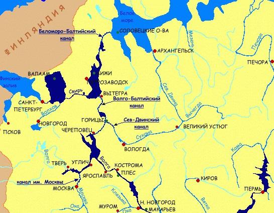
River cruise - an exciting journey on a yacht, boat, boat
The channel is swimming along the Volga, Neva, other rivers, as well as lakes and canals. Comfortable passenger boats run along the main routes. The schedule of their movement provides for stops for travelers to see the sights on the banks of reservoirs and islands. After interesting excursions, tourists relax in cozy cabins, eat in restaurants that offer guests to taste a variety of dishes. Passengers' leisure activities are organized on cruise ships, "green stops" (picnics, swimming, sports and other entertainments) are held on the shore.

Features of the territory along which the Volga-Baltic waterway is laid
The map of the hilly plain, interrupted by swampy depressions of the relief, does not give a complete picture of the amazing landscapes. Meadows and low forests with peat bogs stretch along the banks. The climate of the territory is temperate, but its conditions are slightly different. Here, northerly winds can cause storms, in November they create dangerous conditions for sailing. The current along the entire length of the canal is weak, the average height of wind waves is 1.5 m. The most favorable months for traveling are June and July. Summer in the north-west of Russia is moderately warm, the wind strength and excitement on Ladoga are less. The time of white nights is coming, which allows you to admire the beauty of northern nature around the clock.

Pearls in the "necklace" of the Volga-Baltic route
Ladoga and Onega lakes belong to the group of the largest natural reservoirs in Europe. The basins owe their origin to a glacier that arose more than 100 centuries ago. The maximum depth of Ladoga is more than 230 m, Onega - 120 m. On the shores of the lakes one can see "ram's foreheads" - the so-called boulders processed by the tongues of the glacier.
Picturesque forests and cliffs alternate with sandy beaches. Spruce and pine predominate, birch, aspen, elm, and alder occur. Summer pleases with lush herbage, richness of flowers and berries. The fauna includes dozens of species of mammals and birds, among which there are many waterfowl. Fishing perch, carp and others feel great in water bodies). Ecologically clean lake-forest land, remote from megacities and industrial giants, the Volga-Baltic Canal, as if created for travel and recreation. Ladoga and Onega are not the only natural pearls in the Volga-Balt necklace. White Lake, reservoirs contribute to maintaining the image of a popular recreational area. On the shores there are convenient boat piers, parking lots, cafes, playgrounds and gazebos for recreation.

Fascinating Volga-Baltic travels
The nature of the North-West of the Russian Federation pleases with magnificent views of the lake-forest, swamp and river regions. Reserved places attract hundreds of thousands of travelers. Tourists who travel from St. Petersburg to Moscow and vice versa will see signs of a distant historical past in the very heart of Russia. So, by analogy with the Egyptian desert, inhabited in ancient times by hermits-followers of the early Christian teachings, the monasteries of Belozerye were called "Russian Thebaid".

Popular cruise destinations:
- one-day excursions to the island of Valaam on Lake Ladoga;
- visiting Kizhi Island and the museum-reserve;
- excursions on the ship on the Ladoga and Onega lakes;
- travel along the Volga-Balt with a visit to the capital of Russia and other routes.
Contrasts of the Volga-Balta
Urban landscapes at a distance from St. Petersburg to the east and south, and from Moscow - to the north, are gradually replaced by landscapes of the lake-forest region. Before the eyes of the passengers of a cruise ship or yacht, ancient buildings, wonderful corners of nature float by. While traveling along the Volga-Balt, you can visit St. Petersburg and its suburbs, see the sights of Moscow, monasteries, historical sites - Uglich, Yaroslavl and others.

With spiritual awe, many travelers and pilgrims go to the island of Valaam in the waters of the famous monastery. Above the water surface of the Onega rises the island of Kizhi, the glory of which was created by examples of Russian architecture of the 18th century. As you approach the capital, well-groomed smooth banks and grandiose concrete structures float by, quiet splashes of river water are heard overboard the cruise ship. Tourists get unforgettable impressions from the contrasts of northern nature and urbanized landscapes of the main Russian cities of Moscow and St. Petersburg.
Introduction
Volga-Baltic waterway
Significance of the Volga-Baltic Waterway
Conclusion
List of used literature
Since ancient times, rivers have been the most convenient and inexpensive means of communication on Russian soil. That is why all major cities in Rus' were necessarily based on the banks of rivers. The names of all Russian capitals - Kyiv, Vladimir, St. Petersburg, Moscow - are inextricably linked with the names of the rivers - the Dnieper, Klyazma, Neva, Moscow River.
The importance of river transport in Russia was so great that 205 years ago, in order to maintain its stable operation and planned development, Emperor Paul I established the "Department for the implementation and management of all matters related to water communications." It was the first centralized state service of track facilities and hydraulic structures in the history of Russia.
However, Russian inland waterways improved especially rapidly during the time of developed socialism: in the 30-70s of the last century. It was then that unique inter-basin connections were created (Volga-Baltic, White Sea-Baltic, Volga-Don canals, the Moscow Canal) and chains of reservoirs. Thanks to these hydrotechnical facilities, it was possible to unite all the major rivers of the European part of Russia into a single shipping system.
Not only Moscow, but also dozens of other Russian cities have gained the right to call themselves "ports of the five seas", since it became possible to deliver cheap and unimpeded delivery of goods and passengers along the rivers to the Baltic, White, Black, Azov, Caspian Seas or between them. In the same years, navigation conditions on the rivers of Siberia and the Far East were significantly improved. Russia rightfully had the status of a great river power, since no other country had such an extensive system of inland waterways. But this status has now been irrevocably lost by Russia.
River navigation in Russia is in decline. Over the past decade, thousands of kilometers of river routes have been withdrawn from the category of navigable in Russia. Almost completely lost the navigability of Klyazma. The same fate threatens to befall the Volga-Baltic Canal. The Volga-Baltic Canal is a system of high-pressure locks combined into a canal. It is a single deep-water system that connects five seas. In terms of its length (361 km), the Volga-Baltic Canal exceeds the Panama Canal by four and a half times, and the Suez Canal by two. This facility is federally owned.
Recently, there has been a sharp deterioration in the patency of ships along the canal. The duration of a round trip from Yaroslavl to the seaport of St. Petersburg has increased from 12 to 18 days. The condition of the channel has deteriorated especially sharply over the past five years. If earlier the depth of the canal was guaranteed to be 4 m, now it barely reaches 3 m 60 cm. Therefore, ships have to be not fully loaded. The shallower the depth, the less the ability to fill the holds with cargo. Because of this, the speed of movement also slows down. Being careful, ships move along the canal more slowly than usual. Queues of ships accumulate near the locks. Each ship at stops loses at least a day. Every 10 cm of depth is 200 tons of cargo.
The volume of transported goods decreases, and the profit of ship owners also decreases. Lack of profit leads to the closure of the business. Now the condition of the canal can be called catastrophic: the banks are slipping in places, which does not allow to withstand the dimensions of the ship's passage. According to local authorities and experts, it takes about 300 million rubles a year to maintain the channel in working order, and the amounts allocated by the federal center are ten times less.
The lack of funding directed to support this facility threatens that the Vologda Oblast may be swept away from the face of Russia.
Volga-Baltic Waterway - (former Mariinsky water system) - in the Russian Federation. It connects the Volga with the Baltic Sea, and through the White Sea-Baltic Canal with the White Sea. It passes through the Rybinsk Reservoir. to Cherepovets, Sheksna River, Belozersky Canal, Kovzha, Mariinsky Canal, r. Vytegra, Onega Canal, r. Svir, Lake Ladoga and r. Neva. The Mariinsky water system was built at the beginning. 19th century; since 1964, after a radical reconstruction, the Volga-Baltic waterway. Length approx. 1100 km, depth not less than 4 m. Vessels up to 5000 tons.
Volga-Baltic waterway named after V.V. I. Lenin (former Mariinsky water system), an artificial waterway connecting the Volga with the Baltic Sea, and through the White Sea-Baltic Canal with the White Sea.
Russia's access to the Baltic Sea at the beginning of the 18th century and the growing role of St. Petersburg demanded convenient water communications with the interior regions of the country. 3 waterways were created - the Vyshnevolotsk water system (traffic was opened in 1709), Tikhvin (1811) and Mariinsky (1810). The Mariinsky water system began at Rybinsk, the route went along Sheksna, White Lake, Kovzha, the artificial Mariinsky (later Novomariinsky) Canal, laid through the watershed between the Volga basin and Lake Onega, then along Vytegra, Lake Onega, Svir, Lake Ladoga and Neva (total about 1100 km). The Mariinsky system proper was part of the route from the Volga to Lake Onega. The North Dvina Canal, which departs from Sheksna (opened in 1829), gave access through the Sukhona and the Northern Dvina to the White Sea. The difficulties of navigation of small flat-bottomed vessels on the lakes subsequently forced the construction of bypass canals - Belozersky, Onega and Novoladozhsky. For its time, the Mariinsky system was an outstanding hydraulic structure and was of great economic importance, but by the beginning of the 20th century. it no longer satisfied the transport needs of the country, despite the work carried out at the end of the 19th century. reconstruction.
The creation of a new waterway between Lake Onega and the Volga began after the Great Patriotic War of 1941–45 and began in 1960; June 5, 1964 V.-B. in. item was opened. This route is a link in the unified deep-sea transport system of the European part of the USSR, which ensured the connection of waterways leading to the Baltic, White, Caspian, Black and Azov seas.
The total length of the route between Lake Onega and the city of Cherepovets is 368 km. The path passes in places along the route of the former Mariinsky system, in places deviating somewhat from it. On V.-B. in. n. 5 powerful waterworks with 7 single-chamber single-line locks. On the northern slope, 4 hydroelectric facilities - Vytegorsky, Belousovsky, Novinkovsky and Pakhomovsky - are located on the rise from Lake Onega to the watershed (80 m). The fifth hydroelectric complex (Cherepovetsky) - on the southern slope on Sheksna, 50 km above Cherepovets.
On the northern slope, the route coincides with the channel of the river. Vytegra and passes through reservoirs formed by hydroelectric facilities. The dividing pool stretches from the Pakhomovsky hydroelectric complex on Vytegra to the Cherepovets hydroelectric complex on Sheksna. The navigable route here passes through a watershed canal with a length of 40 km(from the Pakhomovsky hydroelectric complex to the village of Annensky Most), then along the river. Kovzha, White Lake and Sheksna. The route of the southern slope runs along Sheksna, located in the backwater of the Rybinsk reservoir.
V.-B. in. n. is available for vessels with a carrying capacity of about 5000 t, goods are transported without transshipment. Vessels go directly on the lakes (instead of moving along bypass channels). Transportation is dominated by self-propelled cargo ships; rafts are being towed through. The speed of transportation has sharply increased (Cherepovets - Leningrad 2.5-3 day versus 10-15 before reconstruction). The cargo turnover of V.-B. in. n. in comparison with the old Mariinsky system; the proportion of mixed rail-water transportation has increased. The most important cargoes: from the Kola Peninsula (via Kandalaksha) iron ore concentrate to the Cherepovets Metallurgical Combine; Khibiny apatite, apatite concentrate, Karelian granite and diabase to different parts of the country; timber and lumber from the Arkhangelsk and Vologda regions to the South, to the Baltic states, Leningrad and for export; ferrous metal from Cherepovets, Donetsk and Kuznetsk coal, Ural sulfur pyrite, Solikamsk potash salts - for the North-West, the Baltic States and for export; Baskunchak salt (especially for Murmansk); corn. Tankers from the Volga carry oil cargoes for the North-West, the Baltic States and for export. Through Leningrad to V.-B. in. n. import cargoes arrive for different regions of the country. In passenger traffic, there is a significant number of tourist ships (routes from Leningrad to Moscow, Astrakhan, Rostov-on-Don, Perm, etc.).
In 2004, it was forty years since through traffic along the Volga-Baltic Waterway (VBVP) began. Almost simultaneously with the start of operation, intensive reconstruction began to be carried out in order to increase its throughput. As a result of the implementation of several programs on the route, a depth of 4 meters was ensured, with a minimum width of 50-70 meters in some sections. Subject to the conditions of speed limits, divergences and overtaking, it became possible to pass ships with a carrying capacity of up to 5 thousand tons. By the end of the 80s, 45 million tons of soil had been excavated on the route, but the work planned to allow the passage of "five-thousander" motor ships was never completed. finished. By 1990, the capacity of the Volga-Balt had exhausted itself. The volume of traffic in both directions amounted to 15.7 million tons. During this navigation, scientists from the Department of Transport Management of the Volga State Academy of Water Transport, on the instructions of the Volga Shipping Company, performed calculations and assessed the impact of the operation of pushed trains on the capacity of the Volga-Baltic waterway.
Navigation conditions on the Volga-Baltic waterway are extremely difficult. In general, there are 24 sections along 855 km of waterways where certain restrictions on the movement of ships are established. This means divergence at lower speeds, and divergence only on straight sections. There are sections where divergences and overtaking are prohibited. Their total length is 163 km, which is 19.1% of the entire length of the canal. The complexity of navigation is exacerbated by 9 shipping locks with small (compared to the Volga-Kama cascade) dimensions. The access channels of the locks have an insignificant width of the ship's passage, the mooring bollards are either absent or not equipped. But since they were not included in the standard scheme, each of their passage along the VBVP was carried out according to specially developed rules and accompanied by a pilot. The main argument of the channel's specialists, who objected to the inclusion of these trains in the standard scheme, was their length - 170.2 m.
In some sections of the canal, the possibility of their divergence from other vessels is limited. And this causes downtime of ships and thereby reduces the throughput of the Volga-Balt. However, the specialists of the department of navigation of the Volga State Academy of Water Transport, who studied this problem, came to the following conclusion: the actual parameters of the controllability of the pushed convoys cannot serve as an obstacle to their operation on the VBVP. In recent years, there has been an outstripping development of the passenger transportation market compared to freight transportation. Thus, from 1992 to 2003, the traffic flow of the passenger fleet in the alignment of lock No. 1 increased by 76%, while the freight traffic - only by 4%. Taking into account the limited capacity of the channel, a single schedule for the passage of the passenger fleet has been developed. It coordinates the movement of tourist and passenger ships of all shipping companies and determines a locking schedule for two limiting links: the Lower and Upper Svir locks and the cascade of locks N 1-N 6. Thus, for the passage of the passenger fleet through the cascade, 12 planned threads are provided daily .
A comparative analysis of the unified schedules for the movement of passenger ships along the VBVP shows that the loading of navigation facilities due to the passenger fleet in 2004 compared to 2003 increases by 5-7%. This creates the prerequisites for an increase in the number of idle times for the cargo fleet.
Calculations show that three additional heavy-duty trains will not have a serious impact on the state of the throughput of this section and the degree of employment of its navigation pass in the current structure and number of vessels, - Alexander Georgievich Malyshkin, scientific supervisor, head of the department of transport management of the VGAVT, comments on the conclusions of his colleagues.
The design capacity of the canal of 15.5 million tons of cargo for navigation was achieved back in 1978. Its further significant increase in the current technical state of the track (it is assessed as extremely unsatisfactory) and the fleet currently in operation, as well as modern directions of cargo flows, is unrealistic. Use of VBVP gateways over time in 2002-2003 reached 68-72%. If the coefficient exceeds 75%, the waiting time for service will increase sharply, and an almost endless queue of ships will grow.
The trend in the development of the domestic river fleet is such that non-self-propelled tonnage occupies an increasing share in the structure of the cargo fleet for domestic transportation. This is also evidenced by world experience. On the rivers of the United States, for example, there is no self-propelled cargo tonnage at all. Transportation is carried out exclusively on pushed trains. Motor ships of the "Volgo-Don" type are aging and are gradually written off. They are being replaced by push trains. And scientists believe that the Volga-Balta should be prepared for this. When planning the reconstruction of the VBVP, it is necessary to include such parameters in the track characteristics so that they ensure accident-free and efficient operation of the pushed trains. The throughput capacity of the locks is favorably affected by the increase in the average carrying capacity of vessels (convoys) passing along the VBVP. If 2-3 small-tonnage self-propelled vessels with a total carrying capacity of 5 thousand tons are replaced by one pushed one, then the throughput of the lock will increase by 20%.
The operation of an additional three trains on the VBVP will have practically no noticeable effect on the ship's passage, since it will increase the utilization factor over the time of the cascade by only tenths of a percent. If the number of additional trains is increased to five units, Professor Malyshkin is convinced, then the number of fleet demurrages waiting for locking will increase noticeably. To prevent this from happening, scientists propose to carry out the passage of cargo ships along single-track sections along the lines of the schedule, similar to the train schedule. Specialists of the department are ready to take part in the development of such schedules. In addition, they believe that in the foreseeable future, it seems realistic to introduce payment for the passage of channels and locks by ships. But this should be preceded by the development of scientifically based and mutually agreed upon with the railway workers and shipping companies the standards for the passage and locking of ships and trains of all types. When forming a group of ships, the dispatcher will take into account the maximum load of the camera and will definitely think about how to prevent exceeding the norms for the gross time of passage of ships through the channel. The scientists of the academy are also ready to develop standards for following and locking.
river fleet volga baltic canal
The Volga-Baltic Canal consists of nine high-pressure locks, most of which are under the jurisdiction of the Vytegorsky district of hydraulic structures and navigation (VRGiS). All objects of the water system are federal property. Now the leadership of the VRGiS is concerned about the catastrophic state of most of the structures. At the mouth of the Vytegra, dredging is practically not carried out, and this is fraught for ships, which find it difficult to move along the water channel. In the current navigation, there is a big delay in the locking of ships. The transit fleet is forced to stand idle for a long time in the roadstead. In addition, repair work at the locks is not carried out to the extent that is necessary. There is scarce funding.
If the Vytegorsky site needs 177 million rubles a year for maintenance and operation. Only 57 million were allocated from the federal budget in 2004. According to state capital investments, the VRGiS was financed by only 7.5 percent. According to Andrey Semenikhin, director of the VRGiS SUE Volgo-Balt, "The Government of the Russian Federation at the level of the Ministry of Transport should turn its face to hydraulic structures. Not only the Volga-Baltic waterway. In principle, all water channels of the Russian Federation. Since this situation has already become characteristic and for other water transport arteries".
The Volga-Baltic Canal is a single deep-sea system that connects five seas and is one of the largest transport facilities in the world. In length (361 km.) It exceeds the Panama Canal four and a half times, and the Suez Canal twice.
1. V. G. Ermolaev, O. V. Sivakov Law of the Sea. Textbook M., 2004
2. Varelopulo G.A. Organization of traffic and transportation in urban passenger transport. - M.: Transport, 1990.
3. Zhudro A.K. Maritime Law, Moscow, 1974
6. Kuznetsov E.P., Dybov A.M., Sutyrin N.M. Technique and technology of urban sectors: Textbook. - St. Petersburg - Izhevsk. Publishing House of the Institute of Economics and Management of UdGU, 2001.
7. Lobanova E.M. Transport planning of cities. - M.: Transport, 1990.
8. Parakhina V.N. Management of the development of passenger transport as a socio-economic subsystem of the city. - St. Petersburg: SPbGIEA, 1999.
9. Passenger road transportation./Ed. cand. tech. Sciences N.B. Ostrovsky - M.: Transport, 1986.
10. Samoilov D.S. Urban transport. - M.: Stroyizdat, 1983.
11. Sokirkin V.A. International maritime law. Part I-III M., 2006
12. Spirin I.V. City bus transportation: a Handbook. - M.: Transport, 1991.
13. Sutyrin N.M. Planned regulation of the development of the transport complex of the city. In study. allowances: Municipal planning./Ed. V.E. Rokhchin and V.S. Chekalin. - St. Petersburg: SPbGIEA, 1996.
14. Sutyrin N.M., Chekalin V.S. Organization and planning of urban passenger transport: Proc. allowance. - L .: LIEI, 1984.
15. Fishelson M.S. Transport planning of cities. - M.: Higher school, 1985.
Let's continue our virtual journey through waterways, rivers, canals and lakes. I have already told about Kama, the Don and the Volga-Don Canal showed, the way from Moscow to Astrakhan along the Volga led. Now let's go north, along the Sheksna, the Volga-Baltic Canal to Lake Onega.
1. Despite its area, the Rybinsk Reservoir is rather shallow. For the movement of ships, ship passages (No. 63,64,65) were laid, crossing the water area of the reservoir from south to north. I already wrote about the way to Rybinsk, now we are "sailing" to Cherepovets ( True, the photo shows a view in the opposite direction, from it to Rybinsk).
2. Industrial view of Cherepovets from the reservoir. There are many factories in the city, but Severstal plays the leading role, the pipes of which are visible two hours before approaching the city.
3. The Ammophos plant remains on the port side, where an approach navigable canal runs from the Sheksna River (although there is still a backwater reservoir here). You can find out more about this.
4. Pipe CHP EVS-2 on the territory of "Severstal" with a height of about 240 meters.
5. Pier in Cherepovets. Walking "Severstalevsky" "Meteor". High-speed passenger service ceased in the mid-90s. Previously, there were flights to Rybinsk and to Vytegra (Lake Onega), along the entire Volga-Baltic Canal.
6. Oktyabrsky bridge - automobile cable-stayed bridge across the Sheksna. Opened in 1979, it was the first cable-stayed bridge built in Russia. The length of the bridge is 781 m, the height is 83 m.
7. Sheksna - a river in the Vologda region of Russia, a left tributary of the Volga. Length 139 km. It originates from the White Lake, flows into the Rybinsk reservoir. At present, only a small section from the village of Sheksna to the city of Cherepovets has been preserved as a river, since the upper reaches of the river are flooded by the Sheksninskoye reservoir, and the lower by the Rybinsk reservoir.
8. Dawn on Sheksnaya. Some more sunrise photos.
9. Railway bridge over the Sheksna, in the direction of Vologda-Cherepovets.
10. Two-line locks of the Volga-Baltic Canal (No. 7-8) in the city of Sheksna on the river of the same name, raising ships 13 meters above the level of the Rybinsk reservoir. The second string of locks (No. 8) was put into operation in 1990.
12. Sheksninskaya HPP on the Sheksna River in the Vologda Region, near the village of Sheksna. It is part of the Volga-Baltic Canal. The construction of the hydroelectric power station began in 1958 and ended in 1966 (the construction of the second stage took place in 1973-1975). The HPP was built according to the channel scheme.
13. Sheksna is an urban-type settlement. The population is about 20 thousand people. It received its current name in 1954, when, in connection with the development of industrial construction, the village of Nikolskoye was renamed into a workers' settlement. Large forest port.
14. Irma pier on Sheksna, one of the "green" stops on cruises to the North-West.
15. Road bridge near the village of Ivanov Bor. Construction began in the 90s, then stopped and resumed in 2000. Bridge length: approach tracks from the left and right banks are 90 meters each and the main span over the river is 147 meters.
16. A new parking lot on Sheksna - Kuzino, located a little below the bridge. The need for construction arose due to the congestion of ships in the parking lot in Goritsy. From here, tourists will also be transported to the Kirillo-Belozersky Monastery.
17. Shores of Sheksna.
18. Barge under loading at Sheksna.
19. Goritsky Resurrection Monastery - an Orthodox women's monastery in the village of Goritsy, Vologda Region, on the banks of the Sheksna River. From the pier located here, tourists are taken to two places: the Kirillo-Belozersky Monastery and the Ferapontov Monastery.
20. Transport stop.
21. Kirillo-Belozersky Monastery - a male Orthodox monastery on the shores of Lake Siversky, within the boundaries of the modern city of Kirillov, Vologda region. Founded in 1397.
22. Ferapontov Monastery - a monument of history and culture of federal significance in the Vologda region. Famous for the frescoes of Dionysius (1502). UNESCO has included the monastery in the World Heritage List.
23. We return to the river again. The main cargo transported from here to European countries is timber.
24. Ferry across the Sheksna at White Lake in Krokhino.
25. Church of the Nativity in Krokhino, at the beginning of Sheksna in White Lake, built in 1780. Flooded during the creation of the Volga-Baltic waterway. Not restored. Over the past ten years, it has been greatly destroyed, a little more and it will collapse into the water completely.
24. White lake, seagulls and dirt on the lens. White Lake is located in the west of the Vologda region of Russia, has a rounded shape. The city of Belozersk is located on the southwestern coast.
25. White Lake and the beginning of the Kovzha River, along which the waterway passes further.
26. View from Kovzha to White Lake.
27. Kovzha flows out of Lake Kovzhskoye in the northwestern part of the Vologda Oblast. It flows in a natural channel for only the first 10 kilometers.
28. In the area of the village of Aleksandrovskoe, Kovzha connects with the Volga-Baltic Canal, the section of the Volga-Baltic waterway between Aleksandrovskoye and Lake Bely passes along the regulated and artificially deepened Kovzha channel.
29. Night divergence of passenger ships.
31. Beginning of the Volga-Baltic Canal. View of the lock number 6 from Kovzhi.
32. The deepest lock of the Volga-Balt - No. 6 (Pakhomovsky hydroelectric complex).
33. Novinkinsky waterworks - a cascade of locks No. 5, 4, 3.
36. Belousovskoye reservoir between locks No. 3 and 2.
37. Gateway No. 2 (Belousovsky waterworks).
38. We approach Vytegra. View of the Sretenskaya Church from the Vytegorsky reservoir.
39. Berth. On the right, on the shore of the reservoir, there is a museum "Submarine B-440".
40. Gateway No. 1 of the Volga-Baltic Canal in Vytegra.
41. Vytegra - a city (since 1773) in the Vologda region. The population is about 11 thousand people. Forest port in the city of Vytegra on the river of the same name.
42. Vytegra - a river in the Vologda region, part of the Volga-Baltic waterway. It flows out of Matkozero and flows into Lake Onega. The length of the river is 64 km.
43. This is how we got to Lake Onega. Lake Onega is located in the northwest of the European part of the Russian Federation, on the territory of Karelia, the Leningrad and Vologda regions. The second largest lake in Europe. The length from south to north is 245 km, the maximum width is 91.6 km. The average depth is 30 m, and the maximum depth is 127 m. The cities of Petrozavodsk, Kondopoga and Medvezhyegorsk are located on the shores of Lake Onega.
44. About 50 rivers flow into Lake Onega, and only one flows out - the Svir. Traveling along it, Lake Ladoga and the Neva to St. Petersburg will be the next story.
The construction of the new Volga-Baltic waterway was started in 1940, but in 1941, due to the outbreak of World War II, the construction site had to be mothballed. It was resumed after the completion of the shock post-war hydraulic construction - the Volga-Don. After VDSK, a large amount of construction equipment was transferred to the Volga-Balt, the Volgobaltstroy trust was created, but in 1953, after the death of I.V. 1 and no. 2.
In 1955, the Government of the USSR again decided to continue construction, but the customer was no longer the Ministry of Internal Affairs, but the Ministry of the River Fleet, and a condition was put forward to reduce the construction estimate. The designer is Lengidroproekt, since 1956 the chief engineer of the project is G. A. Krylov. Khmelnitsky A. M. was the head of Volgobaltstroy, and Batuner P. D. was the chief engineer.
The project was revised - the number of locks was reduced (instead of 9 locks it became 7), the scheme for erecting a watershed canal was changed - the canal was accepted without fixing the banks, the so-called. "self-transforming" profile, hydromechanization is widely introduced, etc.
Since 1959, the Volga-Baltic waterway has been declared a priority construction project of the seven-year plan. In the last five years of construction, some hydrotechnical problems were solved in a new way.
According to the original project, it was supposed to create a powerful hydroelectric complex with a pumping station on the Volga-Baltic watershed to supply water for the needs of locking. Leningrad engineers proposed instead to lower the level of the canal in the watershed section and create a single watershed pool 270 km long with the inclusion of White Lake in it. It turned, thus, into a reservoir that feeds the entire area with gravity water. True, the volume of earthworks at the same time increased, but the construction of two locks and two dams was excluded, and the reduction in the number of locks not only reduced the cost of construction, but also increased the throughput of the waterway. The need for flooding of the territory was minimized with all the attendant difficulties: the resettlement of residents, the transfer of industrial facilities to new places, the loss of forests and land. Thanks to this decision, in the entire Volga-Balta zone with a length of 360 km, it was necessary to transfer only 218 settlements to new places and cut down forests on an area of 9 thousand hectares. It was also possible to avoid an increase in atmospheric humidity, harmful to the natural conditions of the North-West, from the evaporation of an additional water surface.
At the construction of the Volga-Balt, a kind of record was set for the use of hydromechanization, the cheapest method of excavation. All this taken together - a rational design and economical technology - has significantly reduced the cost of construction.
Scheme of the waterway according to the technical project of 1955
Scheme of the implemented project with a "single pool"

Volga-Baltic Canal


Profile of the Volga-Baltic Canal
Another important feature of the Volga-Balt is that here all the locks of the Baltic slope (with the exception of Pakhomovsky) have the same height - 13.5 m and are completely standardized in design, which made it possible to widely use the benefits of using standardized parts during their construction.
In June 1964, the Volga-Baltic waterway was put into operation. The motor ship "Krasnogvardeets" was the first of the passenger ships along the Volga-Balt. On October 27 of the same year, the government commission accepted the waterway into permanent operation. Somewhat later, he was named after V.I. Lenin. 7 locks, 3 hydroelectric power stations, 5 spillways, 25 earthen dams and dams, 74 km of artificial canals, 35 km of asphalt roads, 384 km of power lines and 10 substations, etc. were built on the canal.
With the construction of the Volga-Baltic Canal, the Volga-Baltic Waterway was closed. This route is a link in the unified deep-sea transport system of the European part of Russia, which provided the connection of waterways leading to the Baltic, White, Caspian, Black and Azov seas.
The total length of the route between Lake Onega and the city of Cherepovets is 368 km. The path passes in places along the route of the former Mariinsky system, in places deviating somewhat from it. On the Volga-Baltic waterway there are 5 powerful waterworks with 7 single-chamber single-line locks. On the northern slope, 4 hydroelectric facilities - Vytegorsky, Belousovsky, Novinkovsky and Pakhomovsky - are located on the rise from Lake Onega to the watershed (80 m). The fifth hydroelectric complex (Cherepovets) is on the southern slope on Sheksna, 50 km above Cherepovets. On the northern slope, the route coincides with the channel of the Vytegra River and passes through reservoirs formed by hydroelectric facilities. The dividing pool stretches from the Pakhomovsky hydroelectric complex on Vytegra to the Cherepovets hydroelectric complex on Sheksna.

The shipping route here runs along a watershed canal 40 km long (from the Pakhomovsky hydroelectric complex to the village of Annensky Most), then along the Kovzha River, White Lake and Sheksna. The route of the southern slope runs along Sheksna, located in the backwater of the Rybinsk reservoir. Excess water resources of the watershed are utilized by the HPP as part of the Sheksna hydroelectric complex with a modern capacity of 84 MW. The fall of the canal on the Northern slope is 80 m (six locks) and on the Southern slope - 13 m - one step on the Sheksna River (since 1989, the second thread of the lock has been operating here - the old No. 7 and the new No. 8 with dimensions of 310 × 21.5 × 5 .5 m).


All locks are reinforced concrete, so-called. “compressed” profile, with chamber dimensions of 270 × 18 m. The depth at the thresholds of the locks and in transit was initially set at 3.65 m and subsequently increased to 4.0 m.
On the northern slope of the canal, two small HPPs with a capacity of 1 and 0.5 MW were built to utilize the local inflow into the lock pools.
The Volga-Baltic Canal is part of and closes the Volga-Baltic Waterway (formerly the Mariinsky Water System) - a system of canals, rivers and lakes in the North-West of the Russian Federation, connecting the Volga with the Baltic Sea. The path passes through the Rybinsk reservoir to the city of Cherepovets, the Sheksna River, the Belozersky Canal, the Kovzha River, the Mariinsky Canal, the Vytegra River, the Onega Canal, Lake Onega, the Svir River, Lake Ladoga and the Neva River.
The length of the route is approximately 1100 km, the depth of the navigable fairway is at least 4 m, which ensures the passage of ships with a displacement of up to 5000 tons.
In general, today the Volgo-Balt is a complex complex of engineering facilities, including 4,900 kilometers of operated waterways, including 3,270 kilometers with guaranteed dimensions, 11 locks with a head of 11 to 18 meters, three hydroelectric power plants, 25 earthen dams and dams, 12 ferry crossings, 9 bridge crossings, 8 lighthouses in Lake Ladoga, more than 5,000 navigation signs.
Cargoes are transported along the Volga-Balt without transshipment. Vessels go directly on the lakes (instead of moving along bypass channels). Transportation is dominated by self-propelled cargo ships; rafts are being towed through. The speed of transportation has sharply increased (travel time from Cherepovets to St. Petersburg is 2.5-3 days versus 10-15 before reconstruction). The cargo turnover of the Volga-Baltic waterway has increased significantly in comparison with the old Mariinsky system.
The estimated capacity of the canal - 15.4 million tons was blocked at the end of the 1980s and now the question arises again about the construction of the second lines of locks No. 1 - 6 on the northern slope of the canal, as well as on the Svir River. Despite the narrow fairway and congestion of ships at the locks, the cargo flow along the Volga-Baltic route is constantly increasing.


